IMAGES TAKEN NEAR TO
Owens Way, GILLINGHAM, ME7 2AW
Introduction
This page details the photographs taken nearby to Owens Way, ME7 2AW by members of the Geograph project.
The Geograph project started in 2005 with the aim of publishing, organising and preserving representative images for every square kilometre of Great Britain, Ireland and the Isle of Man.

There are currently over 7.5m images from over14,400 individuals and you can help contribute to the project by visiting https://www.geograph.org.uk
Image Map
Images are licensed for reuse under creativecommons.org/licenses/by-sa/2.0
Notes
- Clicking on the map will re-center to the selected point.
- The higher the marker number, the further away the image location is from the centre of the postcode.
Image Listing (87 Images Found)
Images are licensed for reuse under creativecommons.org/licenses/by-sa/2.0
Image
Details
Distance

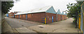
5
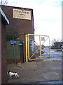
Steelfields Works
At end of Owen's Way Road. These factory buildings block the walker/ cyclist from walking along the River Medway when walking on the Saxon Shore Way (long distance footpath), heading left to The Strand from Eastcourt Meadows, within the Riverside Country Park.
Image: © David Anstiss
Taken: 24 Nov 2008
0.06 miles
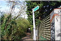
6
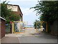
Steelfields Works, Gillingham
Kingsnorth Power Station is in the distance.
Image: © Chris Whippet
Taken: 12 Jun 2009
0.06 miles
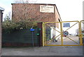
8
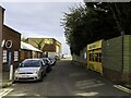
Owens Way, Gillingham
This was originally the entrance to the Gillingham cement plant, which operated intermittently between 1874 and 1939. For details, see www.cementkilns.co.uk/cement_kiln_gillingham.html and related pages. The old, pre-WWI plant was in the land to the right. After WWI, the plant extended onto the west side of the road, and a rotary kiln was built on the land now occupied by Waterside Lane.
Image: © Dylan Moore
Taken: 1 Apr 2014
0.07 miles