IMAGES TAKEN NEAR TO
Maidstone Road, CHATHAM, ME5 9QJ
Introduction
This page details the photographs taken nearby to Maidstone Road, ME5 9QJ by members of the Geograph project.
The Geograph project started in 2005 with the aim of publishing, organising and preserving representative images for every square kilometre of Great Britain, Ireland and the Isle of Man.

There are currently over 7.5m images from over14,400 individuals and you can help contribute to the project by visiting https://www.geograph.org.uk
Image Map
Images are licensed for reuse under creativecommons.org/licenses/by-sa/2.0
Notes
- Clicking on the map will re-center to the selected point.
- The higher the marker number, the further away the image location is from the centre of the postcode.
Image Listing (64 Images Found)
Images are licensed for reuse under creativecommons.org/licenses/by-sa/2.0
Image
Details
Distance
2
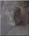
Old Milestone by Maidstone Road, Bluebell Hill village
Carved stone post by the UC road (was B2097), in parish of AYLESFORD (TONBRIDGE AND MALLING District), Maidstone Road, Bluebell Hill village, by No. 512, North of Barling Close, in pavement, in front of brick wall, on West side of road. Rochester stone, erected by the Rochester & Maidstone turnpike trust in the 19th century.
Inscription reads:-
: (MI)LES / XXX / ( ) V :
Kent HER listed.
HER Number: TQ 76 SW 470 https://www.heritagegateway.org.uk/Gateway/Results_Single.aspx?uid=MKE78151&resourceID=1005
Milestone Society National ID: KE_MDRC04.
Image: © C Woodward
Taken: 2 Jun 2008
0.02 miles
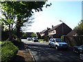
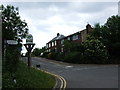
3
Maidstone Road, Blue Bell Hill
This formed part of the A229 between Chatham and Maidstone before it was by-passed in the mid 1980s.
Image: © Chris Whippet
Taken: 11 Jun 2009
0.03 miles
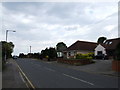
6
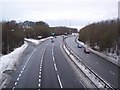
The A229 Dual Carriageway heading to Chatham
This road leads up from Maidstone and the M20 Motorway, it climbs up Blue Bell Hill towards the Medway Towns and the M2 Motorway. Seen from Blue Bell Lane Bridge.
Image: © David Anstiss
Taken: 24 Dec 2009
0.08 miles
7
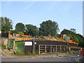
Construction site in Blue Bell Hill village
This was the site of The Upper Bell Inn.
See Image
Strangely, the site has a sign 'Filming and Photography Strictly Prohibited', which I had to just photograph!
Image: © David Anstiss
Taken: 5 Jul 2013
0.09 miles
8
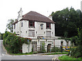
Former Upper Bell Inn, Blue Bell Hill
At junction with Mill Lane. This section Chatham Road is now permanently closed.
Image: © Oast House Archive
Taken: 13 Sep 2010
0.09 miles
9
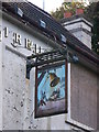
Upper Bell Inn, Pub Sign
On Image, disused pubs.
Image: © David Anstiss
Taken: 14 Oct 2012
0.10 miles
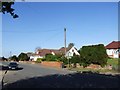
10
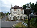
Blue Bell Hill Village sign and disused pub
The Blue Bell Hill Village sign looks well cared for but sadly that is not the case for The Upper Bell Inn just beyond. It was probably built when it was on the main road between Chatham and Maidstone known as Blue Bell Hill which passed to the left and right in front of the pub. Now the road to the right has been closed off and the very busy and noisy A229 passes underneath Common Road just behind where I am standing.
As at 2014 it has now been demolished.
Image: © Marathon
Taken: 1 Aug 2012
0.10 miles