IMAGES TAKEN NEAR TO
Heron Way, CHATHAM, ME5 7RH
Introduction
This page details the photographs taken nearby to Heron Way, ME5 7RH by members of the Geograph project.
The Geograph project started in 2005 with the aim of publishing, organising and preserving representative images for every square kilometre of Great Britain, Ireland and the Isle of Man.

There are currently over 7.5m images from over14,400 individuals and you can help contribute to the project by visiting https://www.geograph.org.uk
Image Map
Images are licensed for reuse under creativecommons.org/licenses/by-sa/2.0
Notes
- Clicking on the map will re-center to the selected point.
- The higher the marker number, the further away the image location is from the centre of the postcode.
Image Listing (33 Images Found)
Images are licensed for reuse under creativecommons.org/licenses/by-sa/2.0
Image
Details
Distance
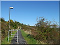
6
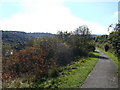
Footpath to Swallow Rise, Princes Park
This long scrubland path leads from Heron Way, towards a road along the valley.
Image: © David Anstiss
Taken: 14 Oct 2012
0.07 miles
10
Footpath to Heron Way, Princes Park
This long scrubland path leads up from Image on Swallow Rise, towards a road on top of the valleyside.
Image: © David Anstiss
Taken: 14 Oct 2012
0.12 miles