IMAGES TAKEN NEAR TO
Rosewell Rise, CHATHAM, ME4 4GF
Introduction
This page details the photographs taken nearby to Rosewell Rise, ME4 4GF by members of the Geograph project.
The Geograph project started in 2005 with the aim of publishing, organising and preserving representative images for every square kilometre of Great Britain, Ireland and the Isle of Man.

There are currently over 7.5m images from over14,400 individuals and you can help contribute to the project by visiting https://www.geograph.org.uk
Image Map (Loading...)


Getting Data...Please wait
Leaflet Map data © OpenStreetMap
Images are licensed for reuse under creativecommons.org/licenses/by-sa/2.0
Notes
- Clicking on the map will re-center to the selected point.
- The higher the marker number, the further away the image location is from the centre of the postcode.
Image Listing (380 Images Found)
Images are licensed for reuse under creativecommons.org/licenses/by-sa/2.0
Image
Details
Distance
1

Former Kitchener Barracks, Dock Road
Planning permission has been approved, with conditions, by Medway Council under application number MC/15/0081 for “change of use of the former Barrack Block to Class C3 (residential) and associated external alterations, change of use of the former Ordnance Store to use Classes A1 (shop), A2 (financial and professional services), A3 (restaurant and cafe), A4 (drinking establishment), B1 (business), D1 (non residential institution) and associated works”.
Viewed from Khartoum Road; these were the Image in July 2019.
Image: © John Baker
Taken: 26 Feb 2020
0.03 miles
2
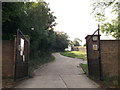
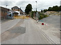
Entrance to Great Lines Heritage Park
As seen from Khartoum Road, leads into Fort Amhurst before heading towards the Fields of Fire near Gillingham.
Image: © David Anstiss
Taken: 1 Sep 2011
0.05 miles
3
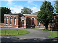
Nursery, Amherst Hill, Brompton
This was surely built as a military building of some sort, but I don't know what. It is now a nursery.
Image: © Danny P Robinson
Taken: 10 Aug 2008
0.06 miles
4
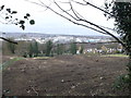
Development Land, Amherst Hill (3)
This large piece of land is between Khartoum Road (in the background) and Maxwell Road.
For ages it has been a patch of wildscrub and trees.
In the background is the River Medway and views towards Strood and Medway City Industrial Estate.
The land on the left, beyond the green fence is part of the Fort Amherst and the Great Lines Heritage Park.
Image: © David Anstiss
Taken: 1 Mar 2013
0.06 miles
5
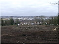
Development Land, Amherst Hill (4)
This large piece of land is between Khartoum Road (in the background) and Maxwell Road.
For ages it has been a patch of wildscrub and trees.
In the background is the River Medway and views towards Strood and Medway City Industrial Estate.
The land on the left, beyond the green fence is part of the Fort Amherst and the Great Lines Heritage Park.
Image: © David Anstiss
Taken: 1 Mar 2013
0.06 miles
6
Former Kitchener Barracks, Dock Road
Planning permission has been approved, with conditions, by Medway Council under application number MC/15/0081 for “change of use of the former Barrack Block to Class C3 (residential) and associated external alterations, change of use of the former Ordnance Store to use Classes A1 (shop), A2 (financial and professional services), A3 (restaurant and cafe), A4 (drinking establishment), B1 (business), D1 (non residential institution) and associated works”.
This is a view from Khartoum Road.
Image: © John Baker
Taken: 21 Jul 2019
0.06 miles
7
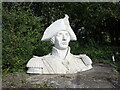
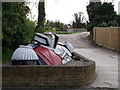
Head of Admiral Nelson
This is to be found at Fort Amherst. The head is about ten feet high and is supposed to be the same height as the one on Nelson's Column.
Fort Amherst, high above Chatham, was constructed in 1756 to protect the southeastern approaches to Chatham Dockyard and the River Medway against a French invasion. Fort Amherst is Britain’s largest and best-preserved Napoleonic Fort. Fort Amherst is now managed and operated by the Fort Amherst Heritage Trust, a Registered Charity, which opens the fort to visitors every day of the year with free access. For more information see https://en.wikipedia.org/wiki/Fort_Amherst
Image: © Marathon
Taken: 23 Sep 2023
0.06 miles
8
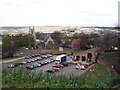
Caveyard Cavern, Fort Amherst
This is the main entrance to Fort Amherst and visitor centre. Tours leave from here to go around the fascinating fort.
In the background, is the disused (and slightly forgotten), St Mary's Church overlooking the River Medway.
Image: © David Anstiss
Taken: 23 Apr 2012
0.07 miles
9
Kitchener statue, Fort Amherst, Chatham
Image: © Chris Whippet
Taken: 19 Jun 2009
0.07 miles
10
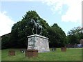
Beheaded, Fort Amherst
A large statue of Lord Nelson beside an access road in Fort Amherst. Its passes by the scout huts in the grounds of the historic fort overlooking Chatham.
Image: © David Anstiss
Taken: 23 Apr 2012
0.07 miles