IMAGES TAKEN NEAR TO
Main Road, ROCHESTER, ME3 8PR
Introduction
This page details the photographs taken nearby to Main Road, ME3 8PR by members of the Geograph project.
The Geograph project started in 2005 with the aim of publishing, organising and preserving representative images for every square kilometre of Great Britain, Ireland and the Isle of Man.

There are currently over 7.5m images from over14,400 individuals and you can help contribute to the project by visiting https://www.geograph.org.uk
Image Map
Images are licensed for reuse under creativecommons.org/licenses/by-sa/2.0
Notes
- Clicking on the map will re-center to the selected point.
- The higher the marker number, the further away the image location is from the centre of the postcode.
Image Listing (41 Images Found)
Images are licensed for reuse under creativecommons.org/licenses/by-sa/2.0
Image
Details
Distance
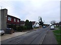
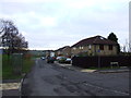
2
Main Road, Chattenden
Looking through Chattenden village, just off the A228.
Image: © Stephen McKay
Taken: 16 Aug 2011
0.03 miles
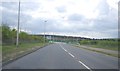
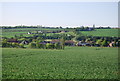
5
Main Road, Chattenden
At the eastern end of Chattenden village Main Road curls round to the roundabout here before continuing to Hoo St Werburgh or giving access to the A228. The chimney at Grain Power Station can be seen in the distance.
Image: © Stephen McKay
Taken: 16 Aug 2011
0.09 miles
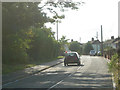
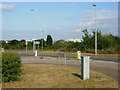
9

A228 towards Grain
A roundabout for a right turn to Hoo is ahead.
Image: © Robin Webster
Taken: 3 Feb 2019
0.12 miles