IMAGES TAKEN NEAR TO
Lower Upnor, ROCHESTER, ME2 4XB
Introduction
This page details the photographs taken nearby to Lower Upnor, ME2 4XB by members of the Geograph project.
The Geograph project started in 2005 with the aim of publishing, organising and preserving representative images for every square kilometre of Great Britain, Ireland and the Isle of Man.

There are currently over 7.5m images from over14,400 individuals and you can help contribute to the project by visiting https://www.geograph.org.uk
Image Map
Images are licensed for reuse under creativecommons.org/licenses/by-sa/2.0
Notes
- Clicking on the map will re-center to the selected point.
- The higher the marker number, the further away the image location is from the centre of the postcode.
Image Listing (162 Images Found)
Images are licensed for reuse under creativecommons.org/licenses/by-sa/2.0
Image
Details
Distance

6
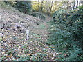
Relic from the Second World War
Situated near to the Saxon Shore Way.
Image: © John Baker
Taken: 2 Nov 2016
0.05 miles
7
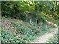
Disused building by course of old railway
Set into the cutting of the old Chattenden and Upnor Railway, latterly run by the Navy, at first sight I took this as a pillbox. However it once was mapped as an electricity substation. A closer look (from a distance) does not convincingly suggest either possibility. The white marker is for a pumped sewer.
Image: © Robin Webster
Taken: 15 Sep 2016
0.05 miles

10
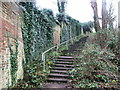
Footsteps leading from Upnor Road leading to Upper Upnor
Image: © Chris Whippet
Taken: 5 Jan 2014
0.06 miles