IMAGES TAKEN NEAR TO
Ordnance Yard, Upnor Road, ROCHESTER, ME2 4AQ
Introduction
This page details the photographs taken nearby to Ordnance Yard, Upnor Road, ME2 4AQ by members of the Geograph project.
The Geograph project started in 2005 with the aim of publishing, organising and preserving representative images for every square kilometre of Great Britain, Ireland and the Isle of Man.

There are currently over 7.5m images from over14,400 individuals and you can help contribute to the project by visiting https://www.geograph.org.uk
Image Map
Images are licensed for reuse under creativecommons.org/licenses/by-sa/2.0
Notes
- Clicking on the map will re-center to the selected point.
- The higher the marker number, the further away the image location is from the centre of the postcode.
Image Listing (310 Images Found)
Images are licensed for reuse under creativecommons.org/licenses/by-sa/2.0
Image
Details
Distance
1
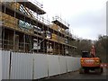
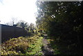
New housing near the Ordnance Depot, Lower Upnor
These timber frames are part of 4 large houses being built on the former brownfield site of a former Naval Ordnance Depot beside the River Medway.
Although, this Image is in the way of the view of the River medway
Image: © David Anstiss
Taken: 12 Feb 2017
0.01 miles
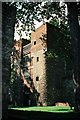
6
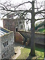
Upnor Castle
This Tudor castle, built in the 16th century, was designed by Sir Richard Lee in order to protect warships that anchored in the River Medway.
Image: © Chris Gunns
Taken: 1 Apr 2007
0.02 miles
7
Upnor Castle
This Tudor castle, built in the 16th century, was designed by Sir Richard Lee in order to protect warships that anchored in the River Medway.
Image: © Chris Gunns
Taken: 1 Apr 2007
0.02 miles
8
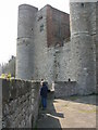
Upnor Castle
This Tudor castle, built in the 16th century, was designed by Sir Richard Lee in order to protect warships that anchored in the River Medway.
Image: © Chris Gunns
Taken: 1 Apr 2007
0.03 miles
9
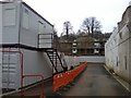
New housing near the Ordnance Depot, Lower Upnor
The wall on the right is part of Image
The timber frame is one of 4 large houses being built on the former brownfield site of a former Naval Ordnance Depot beside the River Medway.
The cabins on the left are site huts for the workers.
Image: © David Anstiss
Taken: 12 Feb 2017
0.03 miles
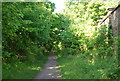
10
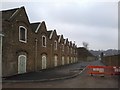
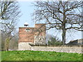
Former B Magazine, Lower Upnor Ordnance Depot
This large building faces the river Medway, is part of the range of disused buildings of the former Ordnance Depot. Once part of H.M. Naval Magazine, then part of the Royal Naval Armament Depots (RNAD) until being sold in 2013.
See http://www.britishlistedbuildings.co.uk/en-500747-building-lu001-former-b-magazine-upnor-d for more details about the Grade II* building.
Beyond the wall (also listed) is the River Medway
Image: © David Anstiss
Taken: 12 Feb 2017
0.03 miles