IMAGES TAKEN NEAR TO
Whittle Walk, WEST MALLING, ME19 4RJ
Introduction
This page details the photographs taken nearby to Whittle Walk, ME19 4RJ by members of the Geograph project.
The Geograph project started in 2005 with the aim of publishing, organising and preserving representative images for every square kilometre of Great Britain, Ireland and the Isle of Man.

There are currently over 7.5m images from over14,400 individuals and you can help contribute to the project by visiting https://www.geograph.org.uk
Image Map
Images are licensed for reuse under creativecommons.org/licenses/by-sa/2.0
Notes
- Clicking on the map will re-center to the selected point.
- The higher the marker number, the further away the image location is from the centre of the postcode.
Image Listing (45 Images Found)
Images are licensed for reuse under creativecommons.org/licenses/by-sa/2.0
Image
Details
Distance
3
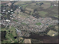
Kings Hill from the air
Kings Hill Cricket Club and Kings Hill Linear Park are prominent.
Image: © Thomas Nugent
Taken: 28 Jan 2022
0.07 miles
9
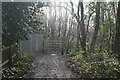
Footpath from Kings Hill West Malling to the Wateringbury-East Malling road.
Kings Hill estate is built on the site of the World War 2 aerodrome. When the aerodrome was built many of the lanes that gave access to it were closed and it was a condition of the planning approval for the houses that these would not be re-opened. This path is one of these closed lanes.
Image: © Ron Lee
Taken: 15 Oct 2016
0.12 miles