IMAGES TAKEN NEAR TO
Francis Lane, WEST MALLING, ME19 4GX
Introduction
This page details the photographs taken nearby to Francis Lane, ME19 4GX by members of the Geograph project.
The Geograph project started in 2005 with the aim of publishing, organising and preserving representative images for every square kilometre of Great Britain, Ireland and the Isle of Man.

There are currently over 7.5m images from over14,400 individuals and you can help contribute to the project by visiting https://www.geograph.org.uk
Image Map
Images are licensed for reuse under creativecommons.org/licenses/by-sa/2.0
Notes
- Clicking on the map will re-center to the selected point.
- The higher the marker number, the further away the image location is from the centre of the postcode.
Image Listing (47 Images Found)
Images are licensed for reuse under creativecommons.org/licenses/by-sa/2.0
Image
Details
Distance
1
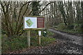
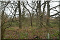
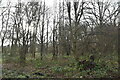
Warren Woods Nature Reserve
This is an area of ancient woodland, regenerating former orchards and open grassland glades and a network of tracks is open to all for low key recreational use, including dog walking and nature walks. It is also used by the Kings Hill school children and local groups, for informal educational purposes and it has an important dual role as an important wildlife refuge and green lung for Kings Hill.
The nature park, which includes areas of dense woodland, is home to a wide range of wildlife including badgers, foxes, bats and the shy and nocturnal dormouse, as well as many woodland birds, reptiles and insects, including an array of butterflies and bees.
Image: © N Chadwick
Taken: 18 Jan 2021
0.04 miles
4
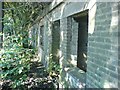
Derelict Airfield Building
This building has been derelict since the nearby airfield ceased its defence role in the Second World War. Outside, it doesn't look too remarkable but inside, there are still reminders of its WW2 use. On one of the walls (seen in the picture through the window) there's a painted area, where planes coming in and out of the airfield were recorded. Some of the pilot's names could still be faintly read chalked on the wall. In the back of the building there was an air raid bunker.
Image: © Hywel Williams
Taken: 10 Jul 2005
0.07 miles
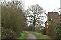
5
The edge of Kings Hill
Kings Hill was developed from 1969 on the site of the former RAF West Malling. This is the eastern edge with Warren Woods Nature Park beyond to the right. Teston Road leads away from here as a track through the woods before becoming a road and leading to the North Pole public house on Wateringbury Road.
Image: © Marathon
Taken: 7 Sep 2015
0.08 miles
7
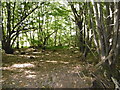
Warren Woods Nature Park
Kings Hill was developed from 1969 on the site of the former RAF West Malling. Beyond the eastern edge is Warren Woods Nature Park which extends across 46 acres of native woodland and was opened to the public in 2011. Teston Road passes through the nature park from Kings Hill as a track before becoming a road and leading to the North Pole public house on Wateringbury Road.
Image: © Marathon
Taken: 7 Sep 2015
0.11 miles
8
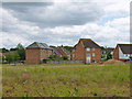
Houses on Monroe Way and Discovery Drive
Monroe Way is on the right, running behind the heap of earth.
Image: © Robin Webster
Taken: 9 Jun 2012
0.11 miles
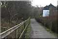
10
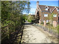
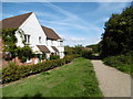
Path bordering the South East part of Kingshill houses
Image: © Ron Lee
Taken: 3 May 2016
0.13 miles