IMAGES TAKEN NEAR TO
High Street, MAIDSTONE, ME18 6HX
Introduction
This page details the photographs taken nearby to High Street, ME18 6HX by members of the Geograph project.
The Geograph project started in 2005 with the aim of publishing, organising and preserving representative images for every square kilometre of Great Britain, Ireland and the Isle of Man.

There are currently over 7.5m images from over14,400 individuals and you can help contribute to the project by visiting https://www.geograph.org.uk
Image Map
Images are licensed for reuse under creativecommons.org/licenses/by-sa/2.0
Notes
- Clicking on the map will re-center to the selected point.
- The higher the marker number, the further away the image location is from the centre of the postcode.
Image Listing (208 Images Found)
Images are licensed for reuse under creativecommons.org/licenses/by-sa/2.0
Image
Details
Distance
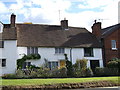
1
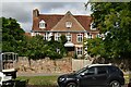
Court Lodge
Grade II* listed. https://historicengland.org.uk/listing/the-list/list-entry/1069066
Image: © N Chadwick
Taken: 22 Aug 2020
0.00 miles
2
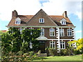
Court Lodge and Dairy House, Yalding
Late 17th century built farmhouse, now Grade II listed house.
See http://www.britishlistedbuildings.co.uk/en-174930-court-lodge-and-the-dairy-house-yalding- for more details about the house.
Image: © David Anstiss
Taken: 4 Oct 2012
0.01 miles
4
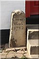
Stone by The Forge
Curious stone about 3ft high by the steps to The Forge in Yalding
Inscribed 'County Work 1782'
Image: © Richard Croft
Taken: 10 Oct 2009
0.02 miles
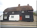
5
Oast Court, Yalding
Narrow lane leading towards Hopgarden Oast and Manna Oast.
See Image
Image: © David Anstiss
Taken: 4 Oct 2012
0.02 miles
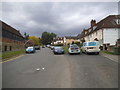
8
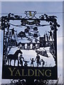
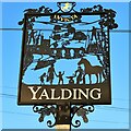
Close up of Yalding Village Sign
This very attractive new sign includes many of the features for which Yalding is well known. These include the medieval town bridge, the church, hop pickers, a gypsy caravan and cattle by the river, oast houses, a canal boat and a blacksmith, as well, of course, of the horse symbol of Kent at the top.
A view of the sign on the other side can be seen at http://www.geograph.org.uk/photo/3164900 and the previous sign can be seen at http://www.geograph.org.uk/photo/1854525
Image: © Marathon
Taken: 1 Apr 2014
0.03 miles
10
Prawle Cottage, Yalding
No 4 and No 5 Yalding High Street, pair of Grade II listed cottages.
See http://www.britishlistedbuildings.co.uk/en-174904-prawle-cottage-yalding-kent for more details about the converted cottage.
Image: © David Anstiss
Taken: 4 Oct 2012
0.03 miles