IMAGES TAKEN NEAR TO
Vicarage Road, MAIDSTONE, ME18 6DS
Introduction
This page details the photographs taken nearby to Vicarage Road, ME18 6DS by members of the Geograph project.
The Geograph project started in 2005 with the aim of publishing, organising and preserving representative images for every square kilometre of Great Britain, Ireland and the Isle of Man.

There are currently over 7.5m images from over14,400 individuals and you can help contribute to the project by visiting https://www.geograph.org.uk
Image Map
Images are licensed for reuse under creativecommons.org/licenses/by-sa/2.0
Notes
- Clicking on the map will re-center to the selected point.
- The higher the marker number, the further away the image location is from the centre of the postcode.
Image Listing (30 Images Found)
Images are licensed for reuse under creativecommons.org/licenses/by-sa/2.0
Image
Details
Distance
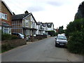
1
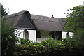
Cherry Tree Cottage
Grade II listed http://list.historicengland.org.uk/resultsingle.aspx?uid=1069016
Image: © Oast House Archive
Taken: 6 Sep 2015
0.03 miles
3
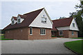
Fosse Bank
New chalet bungalow replacing a much smaller bungalow, currently looking for a new owner.
Image: © Oast House Archive
Taken: 6 Sep 2015
0.06 miles
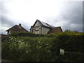
6
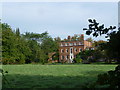
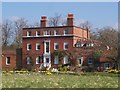
Warde's Moat near Yalding
Warde's Moat was built in 1778 on the site of an older moated residence. The house was a vicarage until 1945 and was said to be the largest vicarage in Kent. It is now separate apartments. For more of its history and photographs see http://yaldinghistory.webplus.net/page169.html It is Grade II Listed.
This view is from the footpath from Yalding to Hunton which passes to the south of the grounds. The shadow of the moat can just be seen in front of the house.
Image: © Marathon
Taken: 12 Oct 2014
0.14 miles

9
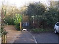
Kissing Gate on Greensand Way
At end of Mount Avenue in Yalding. The long distance path leads towards Coxheath, via footpath No.KM192A to Lughorse Lane
Image: © David Anstiss
Taken: 26 Jan 2009
0.15 miles
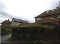
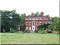
10
Warde's Moat
Moated large house. Seen from footpath between High Street, Yalding and Vicarage Road.
Image: © David Anstiss
Taken: 1 Apr 2009
0.16 miles