IMAGES TAKEN NEAR TO
The Brucks, MAIDSTONE, ME18 5PX
Introduction
This page details the photographs taken nearby to The Brucks, ME18 5PX by members of the Geograph project.
The Geograph project started in 2005 with the aim of publishing, organising and preserving representative images for every square kilometre of Great Britain, Ireland and the Isle of Man.

There are currently over 7.5m images from over14,400 individuals and you can help contribute to the project by visiting https://www.geograph.org.uk
Image Map
Images are licensed for reuse under creativecommons.org/licenses/by-sa/2.0
Notes
- Clicking on the map will re-center to the selected point.
- The higher the marker number, the further away the image location is from the centre of the postcode.
Image Listing (57 Images Found)
Images are licensed for reuse under creativecommons.org/licenses/by-sa/2.0
Image
Details
Distance
5
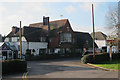
The Wateringbury, Wateringbury
A Chef and Brewer pub on Tonbridge Road.
Image: © Oast House Archive
Taken: 19 Jan 2011
0.09 miles
6
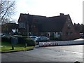
The Wateringbury Pub/Restaurant
On A26 Tonbridge Road. Part of the Chef and Brewer Group. Has a Premier Inn Hotel beside it, seen on left of photo.
Image: © David Anstiss
Taken: 26 Jan 2009
0.10 miles
7
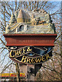
The Wateringbury sign
Image
Depicting oast houses, inspired by those at the Beltring Hop Farm http://www.geograph.org.uk/snippet/76
Image: © Oast House Archive
Taken: 19 Jan 2011
0.10 miles
9
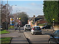
Tonbridge Road
Entering centre of Wateringbury, approaching crossroads with Red Hill and Bow Road.
Image: © Oast House Archive
Taken: 19 Jan 2011
0.11 miles