IMAGES TAKEN NEAR TO
Linton Park, MAIDSTONE, ME17 4AB
Introduction
This page details the photographs taken nearby to Linton Park, ME17 4AB by members of the Geograph project.
The Geograph project started in 2005 with the aim of publishing, organising and preserving representative images for every square kilometre of Great Britain, Ireland and the Isle of Man.

There are currently over 7.5m images from over14,400 individuals and you can help contribute to the project by visiting https://www.geograph.org.uk
Image Map
Images are licensed for reuse under creativecommons.org/licenses/by-sa/2.0
Notes
- Clicking on the map will re-center to the selected point.
- The higher the marker number, the further away the image location is from the centre of the postcode.
Image Listing (63 Images Found)
Images are licensed for reuse under creativecommons.org/licenses/by-sa/2.0
Image
Details
Distance
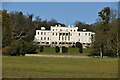

3
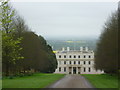
Linton Park seen across its park
In the 1730s Robert Mann built a house which was two-storeyed on the north side and three-storeyed on this (south) side. Horace Walpole described it at the time as "like the citadel of Kent with the whole county as its garden". Shortly before 1829 a third storey was added by Thomas Cubitt and a balustraded terrace was added to the south front. The whole was then stuccoed and painted white. Pevsner describes it: "The effect is as if a section of Carlton House Terrace has been transferred to the hills."
Here it is seen across its park from a footpath. For more information on the history of the house see D Gore's write up at http://www.geograph.org.uk/photo/893507
Image: © Marathon
Taken: 4 Jan 2020
0.01 miles
4
Linton Park seen across its park
In the 1730s Robert Mann built a house which was two-storeyed on the north side and three-storeyed on this (south) side. Horace Walpole described it at the time as "like the citadel of Kent with the whole county as its garden". Shortly before 1829 a third storey was added by Thomas Cubitt and a balustraded terrace was added to the south front. The whole was then stuccoed and painted white. Pevsner describes it: "The effect is as if a section of Carlton House Terrace has been transferred to the hills."
Here it is seen across its park from a footpath. For more information on the history of the house see D Gore's write up at http://www.geograph.org.uk/photo/893507
Image: © Marathon
Taken: 6 Apr 2014
0.01 miles
5
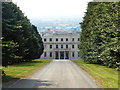
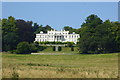
Linton Park, Linton
Viewed from the Greensand Way. Linton Park, formerly Linton Place or Linton Hall, is a large 18th-century country house. Built by Robert Mann in 1730 to replace an earlier building, the house and estate passed through the ownership of several members of Mann's family before coming into the Cornwallis family. The house was enlarged to its current size in 1825.The house is a Grade I listed building and the park is listed Grade II*. Linton Park is now the corporate headquarters of an international agricultural company.
Image: © pam fray
Taken: 17 Aug 2016
0.02 miles
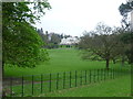
6
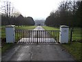
Entrance to Linton Park
As seen from Greensand Way (long distance path) crossing the access drive to the house.
Image: © David Anstiss
Taken: 21 Jan 2009
0.03 miles
7
Linton Park, Linton
The south elevation. Formerly Linton Place or Linton Hall, it is a large 18th-century country house. Built by Robert Mann in 1730 to replace an earlier building, the house and estate passed through the ownership of several members of Mann's family before coming into the Cornwallis family. The house was enlarged to its current size in 1825.The house is a Grade I listed building and the park is listed Grade II*. Linton Park is now the corporate headquarters of an international agricultural company.
Image: © pam fray
Taken: 17 Aug 2016
0.03 miles
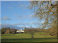
8
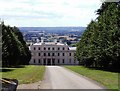
Linton Park
This is the north side of Linton Park with the Low Weald in the background. The south side of the house is shown in the other Geograph. Built in the 1730s, Linton was described at the time as being "like a citadel in Kent, the whole county its garden". It was formerly the home of Lord Cornwallis.
Image: © David Kemp
Taken: 8 Aug 2006
0.04 miles

10
Linton Park from the Greensand Way
In the 1730s Robert Mann built a house which was two-storeyed on this (north) side and three-storeyed on the south side. Horace Walpole described it at the time as "like the citadel of Kent with the whole county as its garden". Shortly before 1829 a third storey was added by Thomas Cubitt and a balustraded terrace was added to the south front. The whole was then stuccoed and painted white. Pevsner describes it: "The effect is as if a section of Carlton House Terrace has been transferred to the hills."
The Greensand Way runs from Haslemere in Surrey to Ham Street on the edge of Romney Marsh. Here it looks towards the north front of Linton Park.
For more information on the history of the house see D Gore's write up at http://www.geograph.org.uk/photo/893507
Image: © Marathon
Taken: 6 Apr 2014
0.08 miles