IMAGES TAKEN NEAR TO
Tolhurst Way, MAIDSTONE, ME17 2BY
Introduction
This page details the photographs taken nearby to Tolhurst Way, ME17 2BY by members of the Geograph project.
The Geograph project started in 2005 with the aim of publishing, organising and preserving representative images for every square kilometre of Great Britain, Ireland and the Isle of Man.

There are currently over 7.5m images from over14,400 individuals and you can help contribute to the project by visiting https://www.geograph.org.uk
Image Map
Images are licensed for reuse under creativecommons.org/licenses/by-sa/2.0
Notes
- Clicking on the map will re-center to the selected point.
- The higher the marker number, the further away the image location is from the centre of the postcode.
Image Listing (180 Images Found)
Images are licensed for reuse under creativecommons.org/licenses/by-sa/2.0
Image
Details
Distance
1
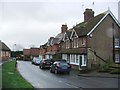
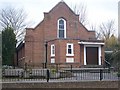
Former church and church hall, Maidstone Road
For sale through Caxtons as a site with development/conversion potential.
After both buildings had been demolished, twenty four dwellings were erected on the site and the development was called Image
Image: © John Baker
Taken: 16 Feb 2014
0.04 miles
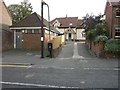
2
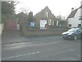
Tolhurst Way, Maidstone Road
Planning permission was granted by Maidstone Borough Council under application number 14/502152/FULL for the “demolition of United Reformed Church and adjoining hall to facilitate the erection of 24 dwellings on this land and land to the south with associated parking, access (from Maidstone Road) and landscaping”.
As the planning application indicates, this housing development was built on the site of a Image
Image: © John Baker
Taken: 19 Nov 2017
0.04 miles
3
Lenham United Reformed Church
On Maidstone Road, opposite town carpark and Dog and Bear Hotel carpark.
Has foundation stone near doorway, which reads 'This stone was laid in the name of the Father. And of the Son. And the Holy Ghost. By Edwin Vinson, Harrietsham.
June 6th 1951'
Image: © David Anstiss
Taken: 22 Feb 2009
0.05 miles
4
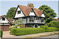
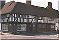
Honywood, High St, Lenham
The house is dated 1621.
Image: © David Kemp
Taken: 5 Jul 2013
0.06 miles
5
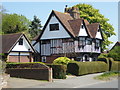
Honywood, High Street, Lenham
Grade II* listed building, dated 1621.
Image: © pam fray
Taken: 21 Apr 2019
0.06 miles
6
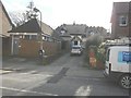
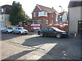
Erection of Bank Yard House, Maidstone Road
Planning permission has been granted with conditions by Maidstone Borough Council under application numbers MA/12/2078 for the “erection of 1.5 storey 3 bedroom dwelling” and MA/10/1349 for the “demolition of redundant workshop and erection of a one and half storey three bedroom chalet bungalow”. It will be very “convenient” for the public toilets as they are situated next door, as can be seen in this view! This was Image in September 2014.
Image: © John Baker
Taken: 16 Feb 2014
0.06 miles
7
Bank Yard House, Maidstone Road
This was the Image in February 2014.
Image: © John Baker
Taken: 14 Sep 2014
0.06 miles
8
Lenham village square ? a typical timbered house
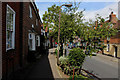
Lenham is a most attractive Kent village. It lies in the shadow of an escarpment rising 300 feet to the chalk Downs in the north, and has the source of the Great Stour river to the south watering its cornfields and orchards. “It has one of Kent’s lovely old squares … an ancient market place. A row of limes throws its shadow across the square on which timbered houses and quaint fronted shops look down.” (‘The King’s England’, Arthur Mee). For the history of the parish and its housing http://www.lenham.net/History/History%20of%20Housing%20in%20Lenham%20P2.htm . Also see the Gallery at: http://www.geograph.org.uk/gallery/trail_of_a_kentish_farming_family_9094 (background family story http://books.google.com/books?id=hrpS_YQ9FoAC&printsec=frontcover&dq=On+Kentish+Chalk )
Image: © D Gore
Taken: Unknown
0.06 miles