IMAGES TAKEN NEAR TO
Ashford Road, MAIDSTONE, ME17 1XE
Introduction
This page details the photographs taken nearby to Ashford Road, ME17 1XE by members of the Geograph project.
The Geograph project started in 2005 with the aim of publishing, organising and preserving representative images for every square kilometre of Great Britain, Ireland and the Isle of Man.

There are currently over 7.5m images from over14,400 individuals and you can help contribute to the project by visiting https://www.geograph.org.uk
Image Map
Images are licensed for reuse under creativecommons.org/licenses/by-sa/2.0
Notes
- Clicking on the map will re-center to the selected point.
- The higher the marker number, the further away the image location is from the centre of the postcode.
Image Listing (13 Images Found)
Images are licensed for reuse under creativecommons.org/licenses/by-sa/2.0
Image
Details
Distance
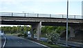
2

Links Fahren - Tenez ? Gauche
As the sliproad from Junction 8 of the M20 passes under the motorway, drivers are reminded that we drive on the left hand side of the road in the UK.
Image: © David Dixon
Taken: 13 May 2013
0.08 miles
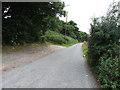
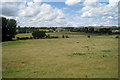
4
Old Mill Lane
The footpath on the left provides a short cut to the A20 which is where the lamp posts are in the middle distance. The North Downs are on the horizon.
Image: © Marathon
Taken: 12 Nov 2013
0.09 miles
5
Footpath from Old Mill Lane
The footpath on the left provides a short cut to the A20 which is where the lamp posts are in the middle distance. The North Downs are on the horizon.
Image: © Marathon
Taken: 12 Nov 2013
0.11 miles
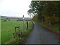
7
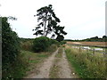
Musket Lane, near Hollingbourne
This lane used to lead from the A20 to Hollingbourne but was stopped up by the construction of the M20.
Image: © Chris Whippet
Taken: 1 Sep 2013
0.17 miles
8
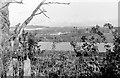
View from Silver Hill
Taken in the days before the high speed channel tunnel rail link and the M20 extension.
The house on the left in the mid-ground is Musketstone, an isolated property on Musket Lane, subsequently removed to make way for the railway. Beyond are the barns of Eyhorne Farm. The two redwoods right of centre are in the grounds of Eyhorne Cottage (a large Georgian house visible to the right of them). The M20 came to an end just out of sight in a cutting to the right. At this time, in the mid 1970s, it only went the 13 miles to Wrotham but its four junctions made it a very useful Maidstone bypass.
Image: © Penny Mayes
Taken: Unknown
0.17 miles
9
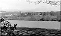
View from Silver Hill
Taken in the days before the high speed channel tunnel rail link and the M20 extension.
The house on the extreme left in the mid-ground is Musketstone, an isolated property on Musket Lane, subsequently removed to make way for the railway. The two redwoods left of centre are in the grounds of Eyhorne Cottage (a large Georgian house visible to the right of them). Just right of centre is Eyhorne House, another Georgian mansion which was demolished within 18 months of this photo being taken.
The M20 came to an end just out of sight in a cutting to the right. At this time, in the mid 1970s, it only went the 13 miles to Wrotham but its four junctions made it a very useful Maidstone bypass.
Image: © Penny Mayes
Taken: Unknown
0.22 miles
10

M20 Junction 8 - Hollingbourne
When the motorway was first built it ran just 15 miles from Wrotham and ended here.
Image: © Penny Mayes
Taken: 17 Jun 2005
0.23 miles