IMAGES TAKEN NEAR TO
Stede Hill, MAIDSTONE, ME17 1NU
Introduction
This page details the photographs taken nearby to Stede Hill, ME17 1NU by members of the Geograph project.
The Geograph project started in 2005 with the aim of publishing, organising and preserving representative images for every square kilometre of Great Britain, Ireland and the Isle of Man.

There are currently over 7.5m images from over14,400 individuals and you can help contribute to the project by visiting https://www.geograph.org.uk
Image Map
Images are licensed for reuse under creativecommons.org/licenses/by-sa/2.0
Notes
- Clicking on the map will re-center to the selected point.
- The higher the marker number, the further away the image location is from the centre of the postcode.
Image Listing (11 Images Found)
Images are licensed for reuse under creativecommons.org/licenses/by-sa/2.0
Image
Details
Distance
1
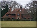
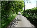
Merlewood Farm House
As seen from footpath from North Downs Way (long distance path) near Hillside Farm to Stede Hill road.
Image: © David Anstiss
Taken: 12 Feb 2009
0.03 miles
3
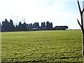
Stede Hill near Merlewood Farm
The winter shadows show the regularity of the planting on the left.
Image: © Penny Mayes
Taken: 31 Jan 2007
0.09 miles
4

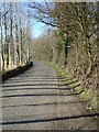
Footpath crosses Stede Hill Road
Footpath from North Downs Way (long distance path) near Hillside Farm, crosses road and leads to Ringlestone Road, near pub 'Ringlestone Inn'.
Image: © David Anstiss
Taken: 12 Feb 2009
0.13 miles
5
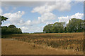
North Downs dip slope plateau south-west of Ringlestone
This part of the dip slope side of the North Downs is characterised by a mixture of dry valleys and plateaux. The footpath can be seen in the foreground.
Image: © David Kemp
Taken: 22 Aug 2020
0.16 miles
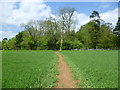
7
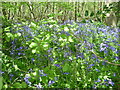
Bluebells in Black Post Wood
This is looking over a fence along the footpath between Ringlestone and Stede Hill.
Image: © Marathon
Taken: 16 May 2015
0.19 miles
8
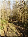
Track through chestnut coppice
Near Merlewood Farm on Stede Hill.
This is sweet chestnut, Castanea sativa, not to be confused with the conker tree or horse chestnut, Aesculus hippocastanum.
Image: © Penny Mayes
Taken: 31 Jan 2007
0.19 miles
9
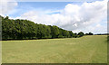
Footpath from Stede Hill to Ringlestone
The footpath runs between Black Post Wood (left) and Redsells Wood (right) across the downland plateau.
Image: © David Kemp
Taken: 22 Aug 2020
0.22 miles
10
Path near Dean's Hill
The footpath leads from Lower Deans Farm around the left hand edge of the wood ahead to reach Stede Hill.
Image: © Marathon
Taken: 16 May 2015
0.23 miles