IMAGES TAKEN NEAR TO
Dean Hill, MAIDSTONE, ME17 1NS
Introduction
This page details the photographs taken nearby to Dean Hill, ME17 1NS by members of the Geograph project.
The Geograph project started in 2005 with the aim of publishing, organising and preserving representative images for every square kilometre of Great Britain, Ireland and the Isle of Man.

There are currently over 7.5m images from over14,400 individuals and you can help contribute to the project by visiting https://www.geograph.org.uk
Image Map (7 Images)


Leaflet Map data © OpenStreetMap
Images are licensed for reuse under creativecommons.org/licenses/by-sa/2.0
Notes
- Clicking on the map will re-center to the selected point.
- The higher the marker number, the further away the image location is from the centre of the postcode.
Image Listing (7 Images Found)
Images are licensed for reuse under creativecommons.org/licenses/by-sa/2.0
Image
Details
Distance
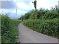
1
Footpath crosses Dean Farm Road
Footpath from North Downs Way (long distance path) near Hillside Farm climbs uphill and then crosses farm road to Ringlestone Road past Merlewood Farm. A path also turns left down farm road into Lower Deans Farm and heads downhill to cross the North Downs Way to go to Goddington.
Image: © David Anstiss
Taken: 12 Feb 2009
0.12 miles
2
Path near Dean's Hill
The footpath leads from Lower Deans Farm around the left hand edge of the wood ahead to reach Stede Hill.
Image: © Marathon
Taken: 16 May 2015
0.14 miles
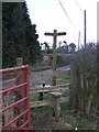
3
Mobile Phone Mast in Lower Deans Farm
Orange Mobile Phone mast is on Dean's Hill, for better coverage. It is seen from footpath through farm from North Downs Way (long distance footpath) to Stede Hill.
Image: © David Anstiss
Taken: 12 Feb 2009
0.14 miles
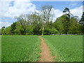
4
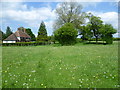
Lower Deans Farm
The footpath here, which has come up from the Pilgrim's Way, crosses a grassy field with a sea of dandelions.
Image: © Marathon
Taken: 16 May 2015
0.15 miles
5

Bluebells
A cleared patch of woodland on the corner of Stede Hill and Hogbarn Lane. The line of Hogbarn Lane can be seen sweeping from right of centre to the woodland back left.
Image: © Penny Mayes
Taken: 29 Apr 2005
0.17 miles
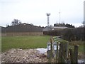
6
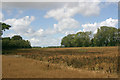
North Downs dip slope plateau south-west of Ringlestone
This part of the dip slope side of the North Downs is characterised by a mixture of dry valleys and plateaux. The footpath can be seen in the foreground.
Image: © David Kemp
Taken: 22 Aug 2020
0.19 miles