IMAGES TAKEN NEAR TO
Padsole Lane, MAIDSTONE, ME15 6ED
Introduction
This page details the photographs taken nearby to Padsole Lane, ME15 6ED by members of the Geograph project.
The Geograph project started in 2005 with the aim of publishing, organising and preserving representative images for every square kilometre of Great Britain, Ireland and the Isle of Man.

There are currently over 7.5m images from over14,400 individuals and you can help contribute to the project by visiting https://www.geograph.org.uk
Image Map
Images are licensed for reuse under creativecommons.org/licenses/by-sa/2.0
Notes
- Clicking on the map will re-center to the selected point.
- The higher the marker number, the further away the image location is from the centre of the postcode.
Image Listing (287 Images Found)
Images are licensed for reuse under creativecommons.org/licenses/by-sa/2.0
Image
Details
Distance
1
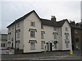
11 - 14 Romney Place, Maidstone
Grade II listed building. Divided into two properties.
A ladies only gym on the left (Gymago) and on the right is Romney Place Clinic.
See http://www.britishlistedbuildings.co.uk/en-173460-11-14-maidstone for more details about the building.
Image: © David Anstiss
Taken: 20 Jul 2011
0.02 miles
2
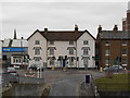
Offices on Romney Place, Maidstone, Kent, ME15 6LE
With numbers 13 and 12 at the centre of the photo.
Image: © Danny P Robinson
Taken: 1 Feb 2015
0.03 miles
3
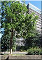
Tower block refurbishment on Wat Tyler Way
Image: © David Howard
Taken: 30 Jun 2018
0.03 miles
4
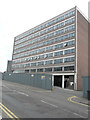
Kent House, Romney Place
Planning permission was granted by Maidstone Borough Council under application number 17/504186/FULL for an “extension to existing building to provide an additional floor for 8 new residential apartments together with associated parking, plus the introduction of an ancillary gym facility on the ground floor for use only of the occupants to residential apartments”.
Image: © John Baker
Taken: 17 Jun 2018
0.03 miles
6
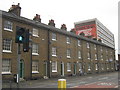
1 - 10 Romney Place
An early to mid C19 Grade II listed terrace on Romney Place.
Most of the houses have been divided into offices.
See http://www.britishlistedbuildings.co.uk/en-173459-1-10-maidstone for more details.
In the background is Kent House office block.
Image: © David Anstiss
Taken: 20 Jul 2011
0.03 miles
7
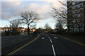
Wat Tyler Way at the junction of Padsole Lane
Image: © David Howard
Taken: 21 Apr 2013
0.04 miles
8
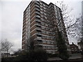
Tower block on Wat Tyler Way, Maidstone
Image: © David Howard
Taken: 19 Mar 2017
0.04 miles
9
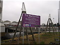
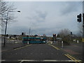
The Mall Garden (under construction), Maidstone
This small plot of land is at the junction of Pad's Hill (leading into Maidstone Bus Station beside the Chequers Shopping Centre - on the left) and Padsole Lane.
In the background is the ramp access to Sainsbury's.
The two plant supports are in the shape of Oast Houses!
Image: © David Anstiss
Taken: 22 Mar 2013
0.04 miles
10
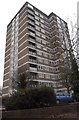
Tower block on Wat Tyler Way, Maidstone
Image: © David Howard
Taken: 19 Mar 2017
0.04 miles