IMAGES TAKEN NEAR TO
Ashford Road, MAIDSTONE, ME14 5DG
Introduction
This page details the photographs taken nearby to Ashford Road, ME14 5DG by members of the Geograph project.
The Geograph project started in 2005 with the aim of publishing, organising and preserving representative images for every square kilometre of Great Britain, Ireland and the Isle of Man.

There are currently over 7.5m images from over14,400 individuals and you can help contribute to the project by visiting https://www.geograph.org.uk
Image Map
Images are licensed for reuse under creativecommons.org/licenses/by-sa/2.0
Notes
- Clicking on the map will re-center to the selected point.
- The higher the marker number, the further away the image location is from the centre of the postcode.
Image Listing (144 Images Found)
Images are licensed for reuse under creativecommons.org/licenses/by-sa/2.0
Image
Details
Distance
3
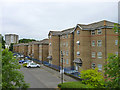
Flats, Riverbank Close, Maidstone
The river being the River Len, behind the buildings.
Image: © Robin Webster
Taken: 27 Jun 2012
0.03 miles
4
Andrew Broughton Way from the junction of Wat Tyler Way
Image: © David Howard
Taken: 21 Apr 2013
0.04 miles
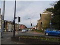
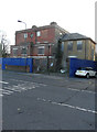
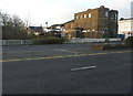
6
Derelict building in Maidstone
On the corner of King Street and Wat Tyler Way.
Image: © Chris Whippet
Taken: 28 Jun 2009
0.05 miles
7
Looking west across Wat Tyler Way
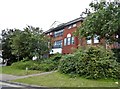
Towards Lenworth House, on the other side of the road, which was built around 1820. It is a large, three storey, detached house, built of yellow stock brick, with the roof hidden behind a parapet. There are two, full height, window bays (one rounded, one canted) facing east towards the former garden (now occupied by Wat Tyler Way). The King Street elevation was refaced in red brick and the openings altered and a two storey, red brick fore-building added in the later 19th century – these alterations have adversely affected the street frontage, whereas east and south elevations remain in an original attractive form. There is a two storey, late 19th century addition in yellow stock brick with a slate roof to the west side http://www.maidstone.gov.uk/__data/assets/pdf_file/0007/19681/Ashford-Road-Appraisal.pdf (scroll down to page 12 to see the original text in the link)
Image: © John Baker
Taken: 27 Nov 2016
0.05 miles
8
Lenworth House, King Street
Lenworth House was built around 1820. It is a large, three storey, detached house, built of yellow stock brick, with the roof hidden behind a parapet. There are two, full height, window bays (one rounded, one canted) facing east towards the former garden (now occupied by Wat Tyler Way). The King Street elevation was refaced in red brick and the openings altered and a two storey, red brick fore-building added in the later 19th century – these alterations have adversely affected the street frontage, whereas east and south elevations remain in an original attractive form. There is a two storey, late 19th century addition in yellow stock brick with a slate roof to the west side http://www.maidstone.gov.uk/__data/assets/pdf_file/0007/19681/Ashford-Road-Appraisal.pdf (scroll down to page 12 to see the original text in the link)
Image: © John Baker
Taken: 27 Nov 2016
0.05 miles
9
Looking west-northwest across Wat Tyler Way
Towards Lenworth House, which was built around 1820. It is a large, three storey, detached house, built of yellow stock brick, with the roof hidden behind a parapet. There are two, full height, window bays (one rounded, one canted) facing east towards the former garden (now occupied by Wat Tyler Way). The King Street elevation was refaced in red brick and the openings altered and a two storey, red brick fore-building added in the later 19th century – these alterations have adversely affected the street frontage, whereas east and south elevations remain in an original attractive form. There is a two storey, late 19th century addition in yellow stock brick with a slate roof to the west side http://www.maidstone.gov.uk/__data/assets/pdf_file/0007/19681/Ashford-Road-Appraisal.pdf (scroll down to page 12 to see the original text in the link)
Image: © John Baker
Taken: 27 Nov 2016
0.05 miles
10
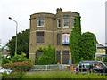
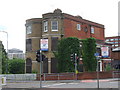
'Freehold Development Opportunity', Maidstone
A building of some age, unlisted nationally. It was mapped as 'Maidstone Ex-Services Club' in 1967, but appears to have been here since Victorian times, apparently just as a house then. It might be called a folly from this aspect, with a bizarre conjunction of semi-circular and semi-octagonal bays. The foreground road is fairly new, built through the building's former grounds.
Image: © Robin Webster
Taken: 27 Jun 2012
0.05 miles