IMAGES TAKEN NEAR TO
Old Chatham Road, MAIDSTONE, ME14 3AJ
Introduction
This page details the photographs taken nearby to Old Chatham Road, ME14 3AJ by members of the Geograph project.
The Geograph project started in 2005 with the aim of publishing, organising and preserving representative images for every square kilometre of Great Britain, Ireland and the Isle of Man.

There are currently over 7.5m images from over14,400 individuals and you can help contribute to the project by visiting https://www.geograph.org.uk
Image Map
Images are licensed for reuse under creativecommons.org/licenses/by-sa/2.0
Notes
- Clicking on the map will re-center to the selected point.
- The higher the marker number, the further away the image location is from the centre of the postcode.
Image Listing (82 Images Found)
Images are licensed for reuse under creativecommons.org/licenses/by-sa/2.0
Image
Details
Distance
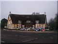
2
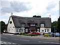
The Running Horse, Sandling
An old pub which has now been converted into a Harvester restaurant.
Image: © Chris Whippet
Taken: 11 Jun 2009
0.03 miles
3
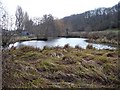
Boxley mill pond
It's been many years since this pond actually fed the mill across the road.
Image: © Penny Mayes
Taken: 5 Jan 2006
0.04 miles
4
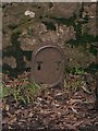
Unusual roadside marker
I would welcome any information on this. The cast iron marker is embedded on the "bridge" over the culvert that carries the outflow from Boxley mill pond into Image
Image: © Penny Mayes
Taken: 5 Jan 2006
0.04 miles
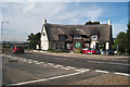
5
The Running Horse, Maidstone
On junction of Sandling Lane and Old Chatham Road. Very popular Harvester pub and restaurant.
Image: © David Anstiss
Taken: 16 Dec 2008
0.05 miles
7
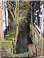
Boxley Mill leat
Image stands on the left, the fire damaged remains of the mill on the right. It is marked on the 19th century map as a cornmill but I think the original mill building must have been much taller than these charred remains suggest. See also Image
Image: © Penny Mayes
Taken: 5 Jan 2006
0.07 miles
8
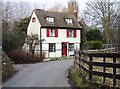
Old Mill House, Boarley Lane, Sandling
Marked on the 19th century map as Boxley Mill (corn). The mill building, to the right of the house, has been destroyed by fire in recent years.
Image: © Penny Mayes
Taken: 5 Jan 2006
0.07 miles
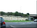
9
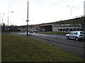
Sandling Lane meets Chatham Road
Part of the complex junction of the A229 Chatham Road with the M20 junction 6 which takes up much of this square. The raised section is the A229. Looking south.
Image: © Penny Mayes
Taken: 5 Jan 2006
0.07 miles