IMAGES TAKEN NEAR TO
Walter Burke Avenue, ROCHESTER, ME1 3YG
Introduction
This page details the photographs taken nearby to Walter Burke Avenue, ME1 3YG by members of the Geograph project.
The Geograph project started in 2005 with the aim of publishing, organising and preserving representative images for every square kilometre of Great Britain, Ireland and the Isle of Man.

There are currently over 7.5m images from over14,400 individuals and you can help contribute to the project by visiting https://www.geograph.org.uk
Image Map
Images are licensed for reuse under creativecommons.org/licenses/by-sa/2.0
Notes
- Clicking on the map will re-center to the selected point.
- The higher the marker number, the further away the image location is from the centre of the postcode.
Image Listing (101 Images Found)
Images are licensed for reuse under creativecommons.org/licenses/by-sa/2.0
Image
Details
Distance
1
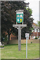
Wouldham Village Sign
On small green on High Street. Village store and post office in background.
Image: © David Anstiss
Taken: 21 Dec 2008
0.01 miles
2
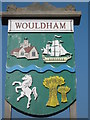
Close-up of Wouldham Village Sign
A close-up of Image It shows Image All Saints Church, a sailing ship , the River Medway (which is to the immediate West of the village), Invicta (the prancing horse symbol of Kent), and hay stacks.
Image: © David Anstiss
Taken: 8 Oct 2010
0.01 miles
4
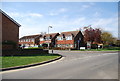
Walter Burke Avenue, Wouldham
Walter Burke is buried in the church yard at Wouldham. He was purser on HMS Victory during the Battle of Trafalgar. Nelson died in his arms.
Image: © N Chadwick
Taken: 15 Apr 2010
0.01 miles
5
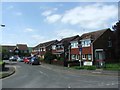
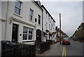
Street scene in Wouldham
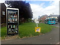
Wouldham is very typical of a village that was built up by industry (like Snodland on the other side of the River Medway). It was the brick works and cement works here that brought in the worker.
This is on the corner of High Street and Walter Burke Avenue. The telephone box is now a book exchange and the village sign is just ahead. See https://www.geograph.org.uk/photo/6934475 for a close up of the latter.
Image: © Marathon
Taken: 14 Aug 2021
0.02 miles
7
Wouldham Village Sign
Depicting Image, a sailing ship, the River Medway (which is to the immediate West of the village), the Invicta horse of Kent, and hay stacks.
Image: © Oast House Archive
Taken: 21 Jun 2010
0.03 miles
8
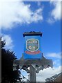
Close up of the village sign in Wouldham
This is a close up of the village sign seen at https://www.geograph.org.uk/photo/6934475 It features the River Medway, the white horse of Kent, the church, a wheatsheaf, a hay cart and a sailing ship.
Image: © Marathon
Taken: 14 Aug 2021
0.03 miles
9
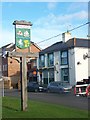
Wouldham High St
On the left is the Foresters Arms.
Image: © N Chadwick
Taken: 30 Aug 2011
0.03 miles
10
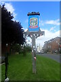
Village sign in Wouldham
Wouldham is very typical of a village that was built up by industry (like Snodland on the other side of the River Medway). It was the brick works and cement works here that brought in the worker.
This is near the corner of High Street and Walter Burke Avenue. A close up can be seen at
Image: © Marathon
Taken: 14 Aug 2021
0.03 miles