IMAGES TAKEN NEAR TO
Rochester Road, ROCHESTER, ME1 3SQ
Introduction
This page details the photographs taken nearby to Rochester Road, ME1 3SQ by members of the Geograph project.
The Geograph project started in 2005 with the aim of publishing, organising and preserving representative images for every square kilometre of Great Britain, Ireland and the Isle of Man.

There are currently over 7.5m images from over14,400 individuals and you can help contribute to the project by visiting https://www.geograph.org.uk
Image Map
Images are licensed for reuse under creativecommons.org/licenses/by-sa/2.0
Notes
- Clicking on the map will re-center to the selected point.
- The higher the marker number, the further away the image location is from the centre of the postcode.
Image Listing (45 Images Found)
Images are licensed for reuse under creativecommons.org/licenses/by-sa/2.0
Image
Details
Distance
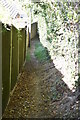
1

Bridleway to Blue Bell Hill
From Rochester Road, Burham. Opposite Court Road.
Goes past Appledore Cottage and disused Quarry.
Bus Shelter surprisingly undamaged by vandals.
Image: © David Anstiss
Taken: 25 Nov 2008
0.03 miles
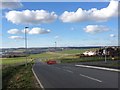
6
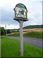
Burham village sign
Prominent on the Burham village sign next to Rochester Road at the southern entrance to the village is Burham Old Church which is some way from the village, down by the River Medway - see http://www.geograph.org.uk/photo/3050156 Also prominent are the North Downs which can be seen beyond the sign here.
Image: © Marathon
Taken: 1 Aug 2012
0.07 miles
7
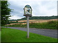
Burham village sign
Prominent on the Burham village sign next to Rochester Road at the southern entrance to the village is Burham Old Church which is some way from the village, down by the River Medway - see http://www.geograph.org.uk/photo/3050156 Also prominent are the North Downs which can be seen beyond the sign here.
Image: © Marathon
Taken: 1 Aug 2012
0.08 miles
9
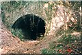
Quarry tunnel at Burham
This tunnel was dug to access a large chalk pit dug into the hillside below Bluebell Hill. The steel gates are open for anyone willing to brave the interior. The pits supplied chalk to APCM's Burham Cement Works (at TQ71876075), which commenced making Portland cement in 1854 and ceased operation in 1938.
Image: © Jack Hill
Taken: 3 Jun 1999
0.08 miles
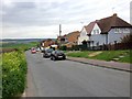
10
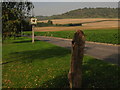
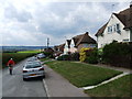
Burham Village Sign and Blue Bell Hill
On Rochester Road, near Whitehouse Crescent looking towards Wouldham. In the foreground is a dead tree carved into a piece of artwork.
Image: © David Anstiss
Taken: 8 Oct 2010
0.08 miles