IMAGES TAKEN NEAR TO
Great Barn Court, Water Lane, ME13 8ZD
Introduction
This page details the photographs taken nearby to Great Barn Court, Water Lane, ME13 8ZD by members of the Geograph project.
The Geograph project started in 2005 with the aim of publishing, organising and preserving representative images for every square kilometre of Great Britain, Ireland and the Isle of Man.

There are currently over 7.5m images from over14,400 individuals and you can help contribute to the project by visiting https://www.geograph.org.uk
Image Map
Images are licensed for reuse under creativecommons.org/licenses/by-sa/2.0
Notes
- Clicking on the map will re-center to the selected point.
- The higher the marker number, the further away the image location is from the centre of the postcode.
Image Listing (129 Images Found)
Images are licensed for reuse under creativecommons.org/licenses/by-sa/2.0
Image
Details
Distance
1
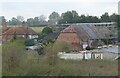
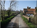
Conversion of historic barns, Queen Court, Ospringe
Two barns in Water Lane are being converted into two large dwellings. Queen Court Farmhouse is on the left. Viewed from Mutton Lane.
Image: © pam fray
Taken: 3 Nov 2021
0.01 miles
2
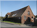
Barn to the North West of Queen Court Farmhouse
On Water Lane near Queen Court Farm.
Grade II listed.
See http://www.britishlistedbuildings.co.uk/en-438521-barn-to-the-north-west-of-queen-court-fa for more details about the barn.
Image: © David Anstiss
Taken: 29 Mar 2014
0.01 miles
3
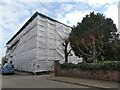
Conversion of barn, Water Lane, Ospringe
Under wraps is the Grade II listed barn in the process of being converted into dwellings.
Image: © pam fray
Taken: 22 Feb 2022
0.01 miles
4
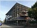
Conversion of historic barns, Queen Court, Ospringe
Two barns in Water Lane are being converted into two large dwellings.
Image: © pam fray
Taken: 7 Nov 2021
0.01 miles
5
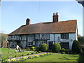
Queen Court Farm
A Grade II* listed building on Water Lane.
See http://www.britishlistedbuildings.co.uk/en-438519-queen-court-farmhouse-and-outbuildings-f for more details about the building.
Image: © David Anstiss
Taken: 29 Mar 2014
0.02 miles
6
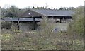
Queen Court Farm, Water Lane, Ospringe
Some of the disused farm buildings. The farmhouse is Grade II* listed together with outbuildings and is now a private home. Steeped in history, the original farm for many years supplied hops to the Shepherd Neame Brewery located in Faversham.
Image: © pam fray
Taken: 4 Feb 2021
0.03 miles
7
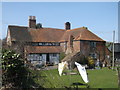
Queen Court Farm
Large Grade II* listed building as seen from Vicarage Lane.
See http://www.britishlistedbuildings.co.uk/en-438519-queen-court-farmhouse-and-outbuildings-f for more details about the building.
Image: © David Anstiss
Taken: 29 Mar 2014
0.03 miles
9
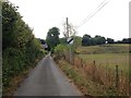
Bridge on Vicarage Lane
This lane leads from Whitehill down to Water Lane in Ospringe.
The bridge passes over an old stream that used to flow from Whitehill through Ospringe, under the A2 (London Road) and through Faversham. It used to flood Ospringe several times a year until the M2 Motorway was built and a culvert was also built to divert the stream.
Queens Court Farm is in the background.
Image: © David Anstiss
Taken: 29 Mar 2014
0.04 miles
10
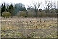
Teasels in Water Lane, Ospringe
On Queen Court Farm, no longer used as farmland. Houses on Mount View, Mutton Lane in the background.
Image: © pam fray
Taken: 22 Feb 2022
0.05 miles