IMAGES TAKEN NEAR TO
Dawsons Row, Water Lane, FAVERSHAM, ME13 8TZ
Introduction
This page details the photographs taken nearby to Dawsons Row, Water Lane, ME13 8TZ by members of the Geograph project.
The Geograph project started in 2005 with the aim of publishing, organising and preserving representative images for every square kilometre of Great Britain, Ireland and the Isle of Man.

There are currently over 7.5m images from over14,400 individuals and you can help contribute to the project by visiting https://www.geograph.org.uk
Image Map
Images are licensed for reuse under creativecommons.org/licenses/by-sa/2.0
Notes
- Clicking on the map will re-center to the selected point.
- The higher the marker number, the further away the image location is from the centre of the postcode.
Image Listing (160 Images Found)
Images are licensed for reuse under creativecommons.org/licenses/by-sa/2.0
Image
Details
Distance
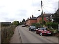
2
Teasels in Water Lane, Ospringe
On Queen Court Farm, no longer used as farmland. Houses on Mount View, Mutton Lane in the background.
Image: © pam fray
Taken: 22 Feb 2022
0.02 miles
3
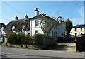
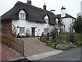
Cottages on Water Lane, Ospringe
The thatched cottages are Grade II listed buildings. Miller's House, on the right, used to be adjacent to a windmill that was dismantled in 1915.
Image: © pam fray
Taken: 5 Mar 2013
0.03 miles
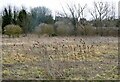
4
Path leading to Joyce Field Allotments from Water Lane
Miller's House is on the left. As the name suggests, there used to be a windmill towering over the house but it was demolished in 1915.
Image: © pam fray
Taken: 22 Feb 2022
0.03 miles
5
Cottages in Water Lane, Ospringe
These cottages used to have a tall windmill behind them, which was demolished in 1915.
Image: © pam fray
Taken: 14 Dec 2008
0.04 miles
6
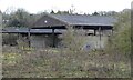
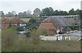
Queen Court Farm, Water Lane, Ospringe
Some of the disused farm buildings. The farmhouse is Grade II* listed together with outbuildings and is now a private home. Steeped in history, the original farm for many years supplied hops to the Shepherd Neame Brewery located in Faversham.
Image: © pam fray
Taken: 4 Feb 2021
0.04 miles
7
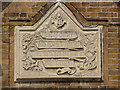
Come, ye children
This inscription, on the wall of Ospringe Primary School, reads "Come, ye children, and hearken unto me. I will teach you the fear of The LORD." Clearly predates the National Curriculum.
Image: © Mike Bremner
Taken: 24 Apr 2011
0.05 miles
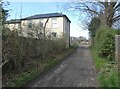
8
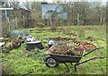
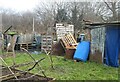
Clearing an allotment plot, Ospringe
The allotments are to the rear of Water Lane and a footpath runs through them to farmland.
Image: © pam fray
Taken: 9 Jan 2021
0.05 miles
9
Conversion of historic barns, Queen Court, Ospringe
Two barns in Water Lane are being converted into two large dwellings. Queen Court Farmhouse is on the left. Viewed from Mutton Lane.
Image: © pam fray
Taken: 3 Nov 2021
0.07 miles
10
Allotments at Ospringe
To the rear of Water Lane with a footpath that runs through them to farmland.
Image: © pam fray
Taken: 9 Jan 2021
0.07 miles