IMAGES TAKEN NEAR TO
Water Lane, FAVERSHAM, ME13 8TT
Introduction
This page details the photographs taken nearby to Water Lane, ME13 8TT by members of the Geograph project.
The Geograph project started in 2005 with the aim of publishing, organising and preserving representative images for every square kilometre of Great Britain, Ireland and the Isle of Man.

There are currently over 7.5m images from over14,400 individuals and you can help contribute to the project by visiting https://www.geograph.org.uk
Image Map
Images are licensed for reuse under creativecommons.org/licenses/by-sa/2.0
Notes
- Clicking on the map will re-center to the selected point.
- The higher the marker number, the further away the image location is from the centre of the postcode.
Image Listing (113 Images Found)
Images are licensed for reuse under creativecommons.org/licenses/by-sa/2.0
Image
Details
Distance
1
![Ospringe houses [3]](https://s3.geograph.org.uk/geophotos/07/05/66/7056699_a734838a_120x120.jpg)
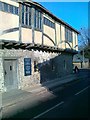
Ospringe houses [3]
Tudor Cottages, nearer the camera, and Orchard House are under the same roof span as Bridge Cottage Image Orchard House is 15th century, timber framed with the ground floor rebuilt in red brick. The first floor is stuccoed with studding and jettied to the street. The north front is weatherboarded. There is another view of Orchard House at Image Tudor Cottages were added in the 16th century, timber framed with the round floor rebuilt in brick. The first floor has exposed framing, plaster infill, and is jettied to the street. There is an overall tiled roof. Listed, grade II, with details at: https://historicengland.org.uk/listing/the-list/list-entry/1360991
Ospringe is a village and area of Faversham, Kent. The village lies on the Roman road Watling Street (now the A2). The historic Maison Dieu fronts onto Watling Street and the remains of substantial Roman buildings, thought to be the site of the Durolevum mentioned in the Antonine Itinerary, have been found nearby.
Image: © Michael Dibb
Taken: 5 Sep 2021
0.00 miles
2
![Ospringe houses [4]](https://s2.geograph.org.uk/geophotos/07/05/67/7056702_05406990_120x120.jpg)
Ospringe houses [4]
A second view of Orchard House, Water Lane. Constructed in the 15th century, timber framed with the ground floor rebuilt in red brick. The first floor is stuccoed with studding and jettied to the street. The north front is weatherboarded. There is another view of Orchard House at Image Listed, with Tudor Cottages, grade II, with details at: https://historicengland.org.uk/listing/the-list/list-entry/1360991
Ospringe is a village and area of Faversham, Kent. The village lies on the Roman road Watling Street (now the A2). The historic Maison Dieu fronts onto Watling Street and the remains of substantial Roman buildings, thought to be the site of the Durolevum mentioned in the Antonine Itinerary, have been found nearby.
Image: © Michael Dibb
Taken: 5 Sep 2021
0.01 miles
3
![Ospringe houses [2]](https://s2.geograph.org.uk/geophotos/07/05/66/7056690_0bf7e679_120x120.jpg)
Ospringe houses [2]
Originally 2 cottages, now one, Bridge Cottage, Water Lane, is under the same roof span as Tudor Cottages and Orchard House Image Probably late 16th or early 17th century, timber framed and clad in red brick in the 18th century, all under a tile roof. Listed, grade II, with details at: https://historicengland.org.uk/listing/the-list/list-entry/1074903
Ospringe is a village and area of Faversham, Kent. The village lies on the Roman road Watling Street (now the A2). The historic Maison Dieu fronts onto Watling Street and the remains of substantial Roman buildings, thought to be the site of the Durolevum mentioned in the Antonine Itinerary, have been found nearby.
Image: © Michael Dibb
Taken: 5 Sep 2021
0.01 miles
4
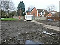
Water Lane demolition site, Ospringe
This was once a bungalow, now a site for what the developers are hoping will provide one 4 bedroom and two 2 bedroom houses.
Image: © pam fray
Taken: 22 Feb 2022
0.02 miles
5
![Ospringe houses [1]](https://s1.geograph.org.uk/geophotos/07/05/66/7056677_7f4c8b76_120x120.jpg)
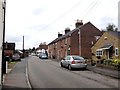
Ospringe houses [1]
Fern Lodge, Water Lane, is an 18th century house, refronted in the early 19th century. Constructed of rendered brick under a tile roof. Listed, grade II, with details at: https://historicengland.org.uk/listing/the-list/list-entry/1074904
Ospringe is a village and area of Faversham, Kent. The village lies on the Roman road Watling Street (now the A2). The historic Maison Dieu fronts onto Watling Street and the remains of substantial Roman buildings, thought to be the site of the Durolevum mentioned in the Antonine Itinerary, have been found nearby.
Image: © Michael Dibb
Taken: 5 Sep 2021
0.02 miles
6
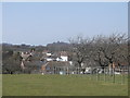
Ospringe in the dip
As seen from a footpath from Mutton Lane to the A2 London Road.
The village of Ospringe is on 2 main roads. The London road (east-west in the photo) and Water Lane (along a valley bottom).
Image: © David Anstiss
Taken: 29 Mar 2014
0.02 miles
8
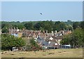
Ospringe rooftops
Viewed from the footpath that runs between London Road and Mutton Lane.
Image: © pam fray
Taken: 30 May 2020
0.04 miles