IMAGES TAKEN NEAR TO
Ospringe Place, FAVERSHAM, ME13 8TB
Introduction
This page details the photographs taken nearby to Ospringe Place, ME13 8TB by members of the Geograph project.
The Geograph project started in 2005 with the aim of publishing, organising and preserving representative images for every square kilometre of Great Britain, Ireland and the Isle of Man.

There are currently over 7.5m images from over14,400 individuals and you can help contribute to the project by visiting https://www.geograph.org.uk
Image Map
Images are licensed for reuse under creativecommons.org/licenses/by-sa/2.0
Notes
- Clicking on the map will re-center to the selected point.
- The higher the marker number, the further away the image location is from the centre of the postcode.
Image Listing (77 Images Found)
Images are licensed for reuse under creativecommons.org/licenses/by-sa/2.0
Image
Details
Distance
1
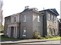
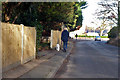
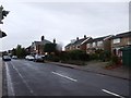
Ospringe Place
On Ospringe Place (road).
A Grade II listed building.
See http://www.britishlistedbuildings.co.uk/en-175928-ospringe-place-faversham-kent for more details.
Image: © David Anstiss
Taken: 29 Mar 2014
0.00 miles
2
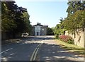
Ospringe Place, Ospringe
A small modern housing development. The house in the photograph is the original Ospringe Place, a Grade II listed late 18th century house built in 1799.
Image: © pam fray
Taken: 30 May 2020
0.01 miles
3
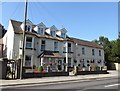
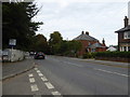
Carnalea Residential Home, Faversham
Situated on London Road (A2) and open since 1985.
Image: © pam fray
Taken: 30 May 2020
0.06 miles
4
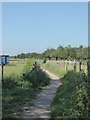
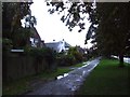
Footpath, Ospringe
Running between London Road (A2) and Mutton Lane in the village of Ospringe
Image: © pam fray
Taken: 30 May 2020
0.09 miles
8
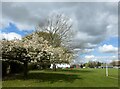
The Mount playing fields, Ospringe
Looking towards The Mount. On the left, over the hedge is the A2 road. The Mount is a large 18th-century house. In 1837 it was occupied by Lieutenant-general Gerard Gosselin who died in 1859 and by 1866 the house was occupied by Percy Beale Neame, a hop farmer who, in 1864, had become a partner in the Faversham brewing business which became known as Shepherd Neame. It was used as a hospital during World War I and after the war it was used as a home for refugee children from Serbia. In 1921 it became a National Children's Home property, closing in the 1930s. The building, which is Grade II listed, was later used as an office by the Ministry of National Insurance and by the Kent Agricultural Emergency Committee. It is now divided into residential flats.
Image: © pam fray
Taken: 11 Apr 2021
0.12 miles
10
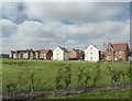
New housing development Faversham
Off the west side of Brogdale Road. There are large developments on both sides of the road. This one is called Orchard Green by Matthew Homes.
Image: © pam fray
Taken: 19 Apr 2020
0.13 miles