IMAGES TAKEN NEAR TO
Ospringe Street, FAVERSHAM, ME13 8FP
Introduction
This page details the photographs taken nearby to Ospringe Street, ME13 8FP by members of the Geograph project.
The Geograph project started in 2005 with the aim of publishing, organising and preserving representative images for every square kilometre of Great Britain, Ireland and the Isle of Man.

There are currently over 7.5m images from over14,400 individuals and you can help contribute to the project by visiting https://www.geograph.org.uk
Image Map
Images are licensed for reuse under creativecommons.org/licenses/by-sa/2.0
Notes
- Clicking on the map will re-center to the selected point.
- The higher the marker number, the further away the image location is from the centre of the postcode.
Image Listing (107 Images Found)
Images are licensed for reuse under creativecommons.org/licenses/by-sa/2.0
Image
Details
Distance
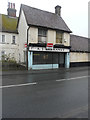
1
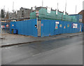
Building site, Ospringe Street
Planning permission was granted by Swale Borough Council under application number 16/505706/FULL for the “demolition of outbuildings and erection of 6 new dwellings and conversion of existing stable building/cold store into a residential dwelling, as amended by drawings received 1 November 2016”.
This image shows a Image, both of which are included in the planning permission.
Image: © John Baker
Taken: 3 Dec 2017
0.01 miles
3
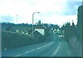
The A2 at Ospringe in 1969
The white car is emerging from Ospringe Road (B2040) onto London Road, which becomes Ospringe Street after this junction.
Image: © John Baker
Taken: Unknown
0.01 miles
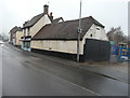
4
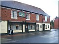
The Ship Public House, Faversham
On the junction of Ospringe Street (A2) and Ospringe Road.
Image: © David Anstiss
Taken: 8 Nov 2008
0.02 miles
5
A J Barkaway, 20, Ospringe Street (A2)
This is a grade II, former butcher’s shop, which is included in the planning permission, which was granted by Swale Borough Council under application number 16/505706/FULL for the “demolition of outbuildings and erection of 6 new dwellings and conversion of existing stable building/cold store into a residential dwelling, as amended by drawings received 1 November 2016”.
Image: © John Baker
Taken: 3 Dec 2017
0.02 miles
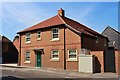
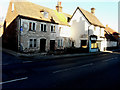
6
Former butcher?s shop & stable building/cold store, Ospringe Street (A2)
The grade II former butcher’s shop was the premises of A J Barkaway and both it and the stable building/cold store are included in the planning permission, which was granted by Swale Borough Council under application number 16/505706/FULL for the “demolition of outbuildings and erection of 6 new dwellings and conversion of existing stable building/cold store into a residential dwelling, as amended by drawings received 1 November 2016”.
To the right of the buildings is a Image, which is included in the planning permission.
Image: © John Baker
Taken: 3 Dec 2017
0.02 miles
7
22, Ospringe Street
The house is attached to Image, a grade II, former butcher’s shop, which is included in the planning permission, which was granted by Swale Borough Council under application number 16/505706/FULL for the “demolition of outbuildings and erection of 6 new dwellings and conversion of existing stable building/cold store into a residential dwelling, as amended by drawings received 1 November 2016”.
Image: © John Baker
Taken: 18 Nov 2018
0.02 miles
8
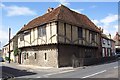
Maison Dieu, Ospringe, Kent
This medieval building formed part of a hospital, royal lodge and almshouse. It now houses Roman artefacts from nearby archaeological sites. It is now owned by English Heritage and is open on weekend afternoons only, March to October.
Image: © Ron Strutt
Taken: 3 Jul 2004
0.02 miles
9
![Ospringe buildings [2]](https://s0.geograph.org.uk/geophotos/07/05/77/7057716_6e688518_120x120.jpg)
Ospringe buildings [2]
Seen here is the front to Ospringe Street of number 17 Ospringe Street, the most substantial surviving portion of the medieval Maison Dieu Hospital. The lower part is 13th century, mostly of flint, but partly rebuilt in red brick. The upper part is early 16th century, timber framed, jettied to the street, the whole under a tile roof. The building has been used as a dwelling, a public house and a shop, but is now a small museum. Listed, grade II*, with details at: https://historicengland.org.uk/listing/the-list/list-entry/1069431 The building is a Scheduled Ancient Monument and there is much detail and history at: https://historicengland.org.uk/listing/the-list/list-entry/1011801
Maison Dieu, the Hospital of Blessed Mary of Ospringe was a hospital, monastery, hostel, retirement home and royal lodge commissioned by Henry III in 1234. Its purpose was to care for the sick and aged. Pilgrimage was the legitimate reason for the poor to travel and the Maison Dieu was the last stop on the journey to Canterbury. Henry III added a Camera Regis or “King’s chamber” to enable royalty to stay at the Maison Dieu and many Kings and Queens stayed here. There is more detail at https://maisondieu.org.uk and at: https://en.wikipedia.org/wiki/Maison_Dieu,_Faversham
Ospringe is a village and area of Faversham, Kent. The village lies on the Roman road Watling Street (now the A2). The historic Maison Dieu fronts onto Watling Street and the remains of substantial Roman buildings, thought to be the site of the Durolevum mentioned in the Antonine Itinerary, have been found nearby.
Image: © Michael Dibb
Taken: 5 Sep 2021
0.02 miles
10
![Ospringe buildings [4]](https://s2.geograph.org.uk/geophotos/07/05/77/7057718_d165d76b_120x120.jpg)
Ospringe buildings [4]
The fine king post roof of number 17 Ospringe Street, the most substantial surviving portion of the medieval Maison Dieu Hospital. The lower part is 13th century, mostly of flint, but partly rebuilt in red brick. The upper part is early 16th century, timber framed, jettied to the street, the whole under a tile roof. The building has been used as a dwelling, a public house and a shop, but is now a small museum. Listed, grade II*, with details at: https://historicengland.org.uk/listing/the-list/list-entry/1069431 The building is a Scheduled Ancient Monument and there is much detail and history at: https://historicengland.org.uk/listing/the-list/list-entry/1011801
Maison Dieu, the Hospital of Blessed Mary of Ospringe was a hospital, monastery, hostel, retirement home and royal lodge commissioned by Henry III in 1234. Its purpose was to care for the sick and aged. Pilgrimage was the legitimate reason for the poor to travel and the Maison Dieu was the last stop on the journey to Canterbury. Henry III added a Camera Regis or “King’s chamber” to enable royalty to stay at the Maison Dieu and many Kings and Queens stayed here. There is more detail at https://maisondieu.org.uk and at: https://en.wikipedia.org/wiki/Maison_Dieu,_Faversham
Ospringe is a village and area of Faversham, Kent. The village lies on the Roman road Watling Street (now the A2). The historic Maison Dieu fronts onto Watling Street and the remains of substantial Roman buildings, thought to be the site of the Durolevum mentioned in the Antonine Itinerary, have been found nearby.
Image: © Michael Dibb
Taken: 5 Sep 2021
0.02 miles