IMAGES TAKEN NEAR TO
Lower Road, FAVERSHAM, ME13 7NE
Introduction
This page details the photographs taken nearby to Lower Road, ME13 7NE by members of the Geograph project.
The Geograph project started in 2005 with the aim of publishing, organising and preserving representative images for every square kilometre of Great Britain, Ireland and the Isle of Man.

There are currently over 7.5m images from over14,400 individuals and you can help contribute to the project by visiting https://www.geograph.org.uk
Image Map (Loading...)


Getting Data...Please wait
Leaflet Map data © OpenStreetMap
Images are licensed for reuse under creativecommons.org/licenses/by-sa/2.0
Notes
- Clicking on the map will re-center to the selected point.
- The higher the marker number, the further away the image location is from the centre of the postcode.
Image Listing (56 Images Found)
Images are licensed for reuse under creativecommons.org/licenses/by-sa/2.0
Image
Details
Distance
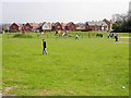
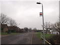
2
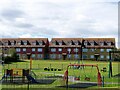
Play area and recreation ground, Faversham
Viewed from Lower Road.
Image: © pam fray
Taken: 19 Sep 2022
0.05 miles
3
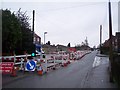
Road Works on Lower Road, Faversham (2)
Lower Road leads from Ospringe Road to various closes to the west of Faversham.
The road works are due to the replacement of a gas main along the road. There have been works along this road, all this year. This section is opposite Willow Avenue. Compare with Image, further down the road.
Image: © David Anstiss
Taken: 17 Jan 2010
0.05 miles
5
Bus Stop on Lower Road near Kiln Court
This is on Lower Road which leads to South Road. The stop is on the Faversham Canterbury Bus. Currently Image, are stopping the buses getting up to here.
Image: © David Anstiss
Taken: 17 Jan 2010
0.06 miles
6
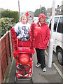
Comic Relief fundraisers on Lower Road
These two brightly coloured ladies have just walked from Sittingbourne to Faversham. Approximately 6 miles walk! They have been sponsored and raising money for Comic Relief. See http://www.comicrelief.com/
Image: © David Anstiss
Taken: 16 Mar 2011
0.07 miles
7
Playground on Sumpter Way
Being well used by these youngsters on their Easter holidays.
Image: © Penny Mayes
Taken: 9 Apr 2007
0.07 miles
9
Unused bus stops on Lower Road, Faversham
These two bus stops are on the Stagecoach Bus route 3 or 3X. The one on the left is the terminus stop. The one on the right is the starting point (after the bus has turned around). The only problem, where does the bus turn? On the left is the entrance to a care home, on the right is the entrance to a social services home, and at the end of the short road is a primary school.
During the week, this road is full of parked cars (at certain times) and it is also difficult (and dangerous for the double-decker bus to turn)!
So Stagecoach, have decided to not use this small section of road and bus stops. They turn at the junction of Lower road and Sumpter Way.
Annoyingly, the application to re-position these bus stops takes at least 6 months to complete. Due to the fact it is altering the bus route... even if only by several 100 metres!
Image: © David Anstiss
Taken: 3 Mar 2012
0.08 miles
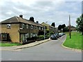
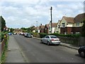
10
View of Lewis Close, Faversham
As seen from Kiln Court.
Image: © David Anstiss
Taken: 25 Dec 2011
0.10 miles