IMAGES TAKEN NEAR TO
Faversham Reach, Upper Brents, FAVERSHAM, ME13 7LA
Introduction
This page details the photographs taken nearby to Faversham Reach, Upper Brents, ME13 7LA by members of the Geograph project.
The Geograph project started in 2005 with the aim of publishing, organising and preserving representative images for every square kilometre of Great Britain, Ireland and the Isle of Man.

There are currently over 7.5m images from over14,400 individuals and you can help contribute to the project by visiting https://www.geograph.org.uk
Image Map
Images are licensed for reuse under creativecommons.org/licenses/by-sa/2.0
Notes
- Clicking on the map will re-center to the selected point.
- The higher the marker number, the further away the image location is from the centre of the postcode.
Image Listing (526 Images Found)
Images are licensed for reuse under creativecommons.org/licenses/by-sa/2.0
Image
Details
Distance
1
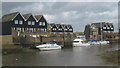
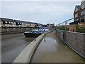
Faversham Reach
Some of the most expensive houses in Faversham, along the Faversham Creek.
Image: © David Anstiss
Taken: 27 Feb 2010
0.02 miles
2
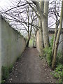
Footpath, Faversham
Between Waterside Close and Upper Brents.
Image: © pam fray
Taken: 3 Apr 2020
0.02 miles
4
Faversham Creek
One of the sailing barges here for the annual Nautical Festival. www.visitkent.co.uk/events/219113
Image: © pam fray
Taken: 23 Jul 2016
0.04 miles
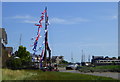
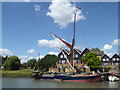
5

Thames sailing barge SB Repertor, Faversham
The traditional sailing barge is here on the creek for the annual Nautical Festival. Viewed from Belvedere Road looking across to Front Brents and Faversham Reach. www.visitkent.co.uk/events/219113
Image: © pam fray
Taken: 24 Jul 2016
0.04 miles
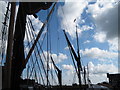
6
The SB Repertor, Front Brents, Faversham Creek
Repertor is one of seven Thames barges built between 1925 and 1930 for F W Horlock, Mistley.
Image: © pam fray
Taken: 29 Jul 2019
0.04 miles
9
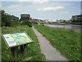
Information board on the Saxon Shore Way at Faversham
Walking around Faversham, the large number of information boards help the visitor learn more about the town and its history. This board, on the west side of Faversham Creek leading out of the town, gives information about the creeks followed by the Saxon Shore Way.
Image: © Marathon
Taken: 14 May 2010
0.05 miles
10
Path by Faversham Creek
New path extension running between Standard Quay and Provender Walk. This is still incomplete as it is still sealed off at the Provender Walk end.
Image: © pam fray
Taken: 2 Nov 2022
0.05 miles