IMAGES TAKEN NEAR TO
Rushett Lane, FAVERSHAM, ME13 0SQ
Introduction
This page details the photographs taken nearby to Rushett Lane, ME13 0SQ by members of the Geograph project.
The Geograph project started in 2005 with the aim of publishing, organising and preserving representative images for every square kilometre of Great Britain, Ireland and the Isle of Man.

There are currently over 7.5m images from over14,400 individuals and you can help contribute to the project by visiting https://www.geograph.org.uk
Image Map
Images are licensed for reuse under creativecommons.org/licenses/by-sa/2.0
Notes
- Clicking on the map will re-center to the selected point.
- The higher the marker number, the further away the image location is from the centre of the postcode.
Image Listing (3 Images Found)
Images are licensed for reuse under creativecommons.org/licenses/by-sa/2.0
Image
Details
Distance
1
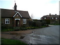
Rushett Lodge
The building to the left, which was built in 1850. The photographer once lived in the house to the right, before it was extended.
Image: © Jonathan Billinger
Taken: 27 Mar 2008
0.02 miles
2
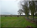
Orchard land at Rushett
The drive to Rushett House curves round to the right.
Image: © Jonathan Billinger
Taken: 27 Mar 2008
0.13 miles
3
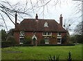
Little Rushett, Rushett Lane, Norton
Originally a 15th century hall house, now a house brick clad in the early 19th century.
Image: © pam fray
Taken: 2 Dec 2020
0.17 miles