IMAGES TAKEN NEAR TO
Faversham Road, FAVERSHAM, ME13 0SE
Introduction
This page details the photographs taken nearby to Faversham Road, ME13 0SE by members of the Geograph project.
The Geograph project started in 2005 with the aim of publishing, organising and preserving representative images for every square kilometre of Great Britain, Ireland and the Isle of Man.

There are currently over 7.5m images from over14,400 individuals and you can help contribute to the project by visiting https://www.geograph.org.uk
Image Map
Images are licensed for reuse under creativecommons.org/licenses/by-sa/2.0
Notes
- Clicking on the map will re-center to the selected point.
- The higher the marker number, the further away the image location is from the centre of the postcode.
Image Listing (13 Images Found)
Images are licensed for reuse under creativecommons.org/licenses/by-sa/2.0
Image
Details
Distance
2

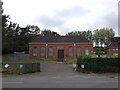
The Lime Works
This former water treatment plant has been converted into a house. See Image for a picture taken five years earlier.
Image: © Mike Bremner
Taken: 25 Apr 2011
0.06 miles
3

Water Tower in Newnham valley
Standing NW of Faversham Road, the style of this building makes it look like a misplaced cinema. I believe it was built in 1936 and is associated with a nearby water board pumping station and may have been an experimental water-softening plant.
2017: I now find this is a listed building https://historicengland.org.uk/listing/the-list/list-entry/1391820 and was indeed built in the 1930s for Mid Kent Water as a water softening plant of a type known as a sludge blanket clarifier. It consists of two conical tanks placed either side of an ellipse-shaped central tower.
It was abandoned during the Second World War, only a decade after its construction, and although it reopened in 1946, it soon closed again, due in part to high operational costs. The building was sold in 2002, and discussions took place about its conversion to domestic use.
In 2003 the 20th Century Society did a case study: https://c20society.org.uk/casework/former-water-softening-plant/
It has since been converted to a six bedroom house - see 2011 photo http://www.geograph.org.uk/photo/2989872 and many more estate agent photos, including interior shots from 2013 http://www.wowhaus.co.uk/2013/10/28/on-the-market-1930s-grade-ii-listed-the-lime-works-six-bedroom-house-in-norton-kent/
The building featured on Channel 4’s Gadget Man.
Image: © Penny Mayes
Taken: 12 May 2006
0.07 miles
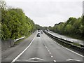
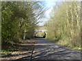
5
The M2 crossing Well Lane
The section of the M2 crossing Well Lane just ahead opened in 1965. For the history of the motorway see https://en.wikipedia.org/wiki/M2_motorway_(Great_Britain)
Image: © Marathon
Taken: 21 Mar 2017
0.15 miles
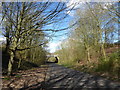
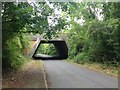
6
M2 Motorway over Mill Lane
M2 Motorway heads left over road, heading to Faversham/Canterbury from Sittingbourne/London. Mill Lane heads under the bridge to Faversham Road, from Painters Forstal.
Image: © David Anstiss
Taken: 12 Apr 2009
0.16 miles
7
The M2 crossing Well Lane
The section of the M2 crossing Well Lane just ahead opened in 1965. For the history of the motorway see https://en.wikipedia.org/wiki/M2_motorway_(Great_Britain)
Image: © Marathon
Taken: 21 Mar 2017
0.16 miles
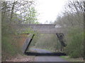
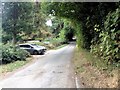
8
Well Lane, Painters Forstal
The bridge carries the M2 Motorway.
Image: © Chris Whippet
Taken: 20 Sep 2016
0.17 miles
10

The green menace
Green fly on sycamore beside Faversham Road. The M2 viaduct may be seen in the background.
Image: © Penny Mayes
Taken: 12 May 2006
0.21 miles