IMAGES TAKEN NEAR TO
Syndale Valley, FAVERSHAM, ME13 0RP
Introduction
This page details the photographs taken nearby to Syndale Valley, ME13 0RP by members of the Geograph project.
The Geograph project started in 2005 with the aim of publishing, organising and preserving representative images for every square kilometre of Great Britain, Ireland and the Isle of Man.

There are currently over 7.5m images from over14,400 individuals and you can help contribute to the project by visiting https://www.geograph.org.uk
Image Map
Images are licensed for reuse under creativecommons.org/licenses/by-sa/2.0
Notes
- Clicking on the map will re-center to the selected point.
- The higher the marker number, the further away the image location is from the centre of the postcode.
Image Listing (13 Images Found)
Images are licensed for reuse under creativecommons.org/licenses/by-sa/2.0
Image
Details
Distance
1
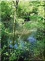
Pool in Putt Wood
On the NW edge of the wood in the SE corner of the square. I would not have known this pool was here had it not been for the Danger Deep Water sign. It is fenced off as, from this edge at least, it forms a precipitous drop with a man-made stone edging. Water level seemed low, however, as the drought persists.
Image: © Penny Mayes
Taken: 12 May 2006
0.13 miles
2
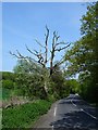
Dead tree on Faversham Road
Trees on the right form the NW edge of Putt Wood. The shrub/tree beside the dead one is another of these http://www.geograph.org.uk/photo/170629 and its fluffy seeds were floating around everywhere.
Image: © Penny Mayes
Taken: 12 May 2006
0.13 miles
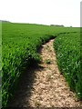
3
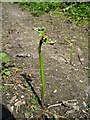
Burgeoning bracken
On a ride in Putt Wood.
Image: © Penny Mayes
Taken: 12 May 2006
0.13 miles
4
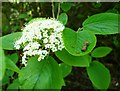
Wayfaring tree
I think I've identified this correctly although the leaves don't look quite right. Any help to confirm or otherwise much appreciated.
Image: © Penny Mayes
Taken: 12 May 2006
0.13 miles
5
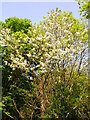
Wild cherry
Growing on a field boundary north of Faversham Road in the SE corner of the square.
Image: © Penny Mayes
Taken: 12 May 2006
0.15 miles
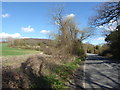
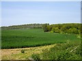
6
Wheat field near Provender
North of the Faversham Road. The higher parts of this field are marked as orchard on the map and nearby poplar windbreaks are another pointer to this former usage. The wood on the brow of the slope is Provender Wood.
Image: © Penny Mayes
Taken: 12 May 2006
0.16 miles
7
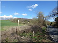
View from Faversham Road
Middle Wood can be seen up the hill in the distance. A footpath to Provender Farm follows the edge of the field just ahead. Faversham Road is on the right.
Image: © Marathon
Taken: 21 Mar 2017
0.19 miles
8
Footpath to Provender Farm
Middle Wood can be seen up the hill. The footpath to Provender Farm follows the edge of the field just ahead. Faversham Road is on the right.
Image: © Marathon
Taken: 21 Mar 2017
0.19 miles
9
Farmland SE of Provender
Wheat and managed woodland north of Faversham Road.
Image: © Penny Mayes
Taken: 12 May 2006
0.20 miles