IMAGES TAKEN NEAR TO
Colegates Close, FAVERSHAM, ME13 0QQ
Introduction
This page details the photographs taken nearby to Colegates Close, ME13 0QQ by members of the Geograph project.
The Geograph project started in 2005 with the aim of publishing, organising and preserving representative images for every square kilometre of Great Britain, Ireland and the Isle of Man.

There are currently over 7.5m images from over14,400 individuals and you can help contribute to the project by visiting https://www.geograph.org.uk
Image Map
Images are licensed for reuse under creativecommons.org/licenses/by-sa/2.0
Notes
- Clicking on the map will re-center to the selected point.
- The higher the marker number, the further away the image location is from the centre of the postcode.
Image Listing (291 Images Found)
Images are licensed for reuse under creativecommons.org/licenses/by-sa/2.0
Image
Details
Distance
1
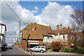
![Oare houses [3]](https://s1.geograph.org.uk/geophotos/07/05/59/7055997_0d492b8a_120x120.jpg)
Oare houses [3]
Mount House, Mount Pleasant, is a 17th century timber framed house. Clad in mathematical tiles in the early 19th century, all under a tile roof. Listed, grade II, with details at: https://historicengland.org.uk/listing/the-list/list-entry/1069099
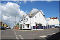
Oare is a low lying village on the bank of Oare Creek, just over one mile northwest of Faversham. To the north are the Oare Marshes, a nature reserve, an important stopping place for migratory birds. Oare was the southern terminus of the Harty Ferry, which ran across the Swale channel between the Isle of Harty and the mainland. Huguenot refugees founded Oare gunpowder works around 1690 using their knowledge of the advanced French gunpowder.
Image: © Michael Dibb
Taken: 5 Sep 2021
0.05 miles
3
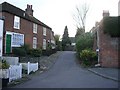
Mount Pleasant, Oare
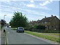
This is a tiny lane off The Street and opposite the corner of Church Road.
Image: © pam fray
Taken: 1 Dec 2007
0.05 miles
5
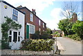
![Oare houses [1]](https://s0.geograph.org.uk/geophotos/07/05/59/7055992_82969ded_120x120.jpg)
Oare houses [1]
King Alfred House, number 1 Mount Pleasant, was built in the early 19th century. Constructed of painted brick under a slate roof. Listed, for group value, grade II, with details at: https://historicengland.org.uk/listing/the-list/list-entry/1121868
Oare is a low lying village on the bank of Oare Creek, just over one mile northwest of Faversham. To the north are the Oare Marshes, a nature reserve, an important stopping place for migratory birds. Oare was the southern terminus of the Harty Ferry, which ran across the Swale channel between the Isle of Harty and the mainland. Huguenot refugees founded Oare gunpowder works around 1690 using their knowledge of the advanced French gunpowder.
Image: © Michael Dibb
Taken: 5 Sep 2021
0.06 miles
6
![Oare houses [2]](https://s0.geograph.org.uk/geophotos/07/05/59/7055996_22fdd4fa_120x120.jpg)
Oare houses [2]
Numbers 2 and 3 Mount Pleasant were originally one house, now two. A 17th century timber framed building, clad in brick in the 19th century, all under a tile roof. The shop window and the extension on the right are 20th century. Listed, grade II, with details at: https://historicengland.org.uk/listing/the-list/list-entry/1344021
Oare is a low lying village on the bank of Oare Creek, just over one mile northwest of Faversham. To the north are the Oare Marshes, a nature reserve, an important stopping place for migratory birds. Oare was the southern terminus of the Harty Ferry, which ran across the Swale channel between the Isle of Harty and the mainland. Huguenot refugees founded Oare gunpowder works around 1690 using their knowledge of the advanced French gunpowder.
Image: © Michael Dibb
Taken: 5 Sep 2021
0.06 miles