IMAGES TAKEN NEAR TO
Park Terrace, FAVERSHAM, ME13 0PH
Introduction
This page details the photographs taken nearby to Park Terrace, ME13 0PH by members of the Geograph project.
The Geograph project started in 2005 with the aim of publishing, organising and preserving representative images for every square kilometre of Great Britain, Ireland and the Isle of Man.

There are currently over 7.5m images from over14,400 individuals and you can help contribute to the project by visiting https://www.geograph.org.uk
Image Map
Images are licensed for reuse under creativecommons.org/licenses/by-sa/2.0
Notes
- Clicking on the map will re-center to the selected point.
- The higher the marker number, the further away the image location is from the centre of the postcode.
Image Listing (35 Images Found)
Images are licensed for reuse under creativecommons.org/licenses/by-sa/2.0
Image
Details
Distance
1
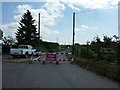
Almshouse Road is closed
From the 16th May for a fortnight, which must be very inconvenient for drivers but not a problem for walkers as there is a footpath nearby.
Image: © pam fray
Taken: 20 May 2011
0.06 miles
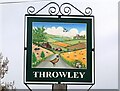
2
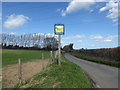
The village sign for Throwley
The sign is actually closer to Throwley Forstal than Throwley. It does not appear on Street View from June 2009 and looks new. It is a delightful and colourful and a close-up can be seen at http://www.geograph.org.uk/photo/5320826
Image: © Marathon
Taken: 21 Mar 2017
0.08 miles
3

Lunchtime, Throwley
Sheep with her twin lambs.
Image: © pam fray
Taken: 18 Apr 2022
0.08 miles
4

Sheep and lamb, Throwley
Viewed from the road leading to Throwley Forstal.
Image: © pam fray
Taken: 18 Apr 2022
0.08 miles
5

Throwley Forstal
Throwley lies on top of the Kent North Downs and consists of mainly arable fields and woodland copses covering just over 5 square miles. The population is scattered across a number of hamlets, the largest of which is Throwley Forstal.
Image: © pam fray
Taken: 18 Apr 2022
0.08 miles
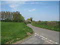
6
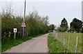
The road to Throwley Forstal
Throwley lies on top of the Kent North Downs and consists of mainly arable fields and woodland copses covering just over 5 square miles. The population is scattered across a number of hamlets, the largest of which is Throwley Forstal.
Image: © pam fray
Taken: 18 Apr 2022
0.09 miles
7
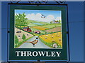
Close up of the village sign for Throwley
This is a close up of the sign seen at http://www.geograph.org.uk/photo/5320823 Wildlife features with badgers, a pheasant and hedgehogs. Birds of prey circle with the church of St Michael and All Angels Church, Throwley in the distance - see http://www.geograph.org.uk/photo/5319594
Image: © Marathon
Taken: 21 Mar 2017
0.09 miles
9
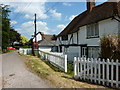
Whitings House and the Old Post Office, The Green, Throwley Forstal
Both houses are 15th century Grade II listed buildings. The K6 telephone kiosk by the Old Post Office is also Grade II listed.
Image: © pam fray
Taken: 20 May 2011
0.09 miles
10
Village sign, Throwley Forstal
On the lane to Throwley.
Image: © pam fray
Taken: 18 Apr 2022
0.09 miles