IMAGES TAKEN NEAR TO
Throwley, FAVERSHAM, ME13 0PE
Introduction
This page details the photographs taken nearby to ME13 0PE by members of the Geograph project.
The Geograph project started in 2005 with the aim of publishing, organising and preserving representative images for every square kilometre of Great Britain, Ireland and the Isle of Man.

There are currently over 7.5m images from over14,400 individuals and you can help contribute to the project by visiting https://www.geograph.org.uk
Image Map
Images are licensed for reuse under creativecommons.org/licenses/by-sa/2.0
Notes
- Clicking on the map will re-center to the selected point.
- The higher the marker number, the further away the image location is from the centre of the postcode.
Image Listing (48 Images Found)
Images are licensed for reuse under creativecommons.org/licenses/by-sa/2.0
Image
Details
Distance
2
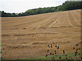
Harvested field by Bagshill Road
Image: © Oast House Archive
Taken: 19 Aug 2011
0.11 miles
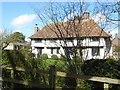
3
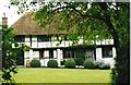
Timber-frame building Throwley
See the Gallery at: http://www.geograph.org.uk/gallery/trail_of_a_kentish_farming_family_9094
(background family story http://books.google.com/books?id=hrpS_YQ9FoAC&printsec=frontcover&dq=On+Kentish+Chalk )
Image: © D Gore
Taken: Unknown
0.13 miles
5
Church House, Throwley
Church House is seen from the avenue leading up to St Michael and All Angels Church, Throwley - see http://www.geograph.org.uk/photo/5319605
Image: © Marathon
Taken: 21 Mar 2017
0.15 miles
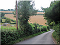
6
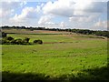
View northwest from Parsonage Farm
The straight hedge line marks the course of a footpath which runs up to the golf club in the north of the square http://www.geograph.org.uk/photo/239786 Belmont House http://www.geograph.org.uk/photo/239775 lies beyond the trees on the horizon to the left.
Image: © Penny Mayes
Taken: 26 Sep 2006
0.17 miles
7

St. Michael and All Angels church, Throwley
A medieval Grade I listed building, restored in 1866.
Image: © pam fray
Taken: 20 May 2011
0.17 miles
8
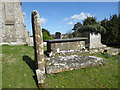
Tombs in the churchyard of St Michael and All Angels, Throwley
Approached up a short avenue off Throwley Road, the tower of St Michael and All Angels Church can be seen from a considerable distance around - see http://www.geograph.org.uk/photo/5319605 The tower dates from the 14th century but was heightened in 1866. There is a Norman west doorway and originally there was an aisleless Norman church. The church reached its present shape in the 14th century but clearly there was the usual 19th century restoration.
Image: © Marathon
Taken: 21 Mar 2017
0.18 miles
9
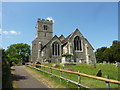
St. Michael and All Angels church, Throwley
A Grade I listed medieval building restored in 1866.
Image: © pam fray
Taken: 20 May 2011
0.18 miles
10
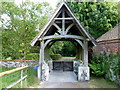
Lych gate of St. Michael and All Angels church
Looking towards Throwley Road.
Image: © pam fray
Taken: 20 May 2011
0.18 miles