IMAGES TAKEN NEAR TO
Wing Road, SHEERNESS, ME12 4RR
Introduction
This page details the photographs taken nearby to Wing Road, ME12 4RR by members of the Geograph project.
The Geograph project started in 2005 with the aim of publishing, organising and preserving representative images for every square kilometre of Great Britain, Ireland and the Isle of Man.

There are currently over 7.5m images from over14,400 individuals and you can help contribute to the project by visiting https://www.geograph.org.uk
Image Map
Images are licensed for reuse under creativecommons.org/licenses/by-sa/2.0
Notes
- Clicking on the map will re-center to the selected point.
- The higher the marker number, the further away the image location is from the centre of the postcode.
Image Listing (46 Images Found)
Images are licensed for reuse under creativecommons.org/licenses/by-sa/2.0
Image
Details
Distance
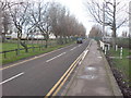
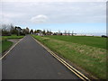
6
Shellness Road approaching Leysdown Coastal Park
The car park on the left is gated and shut off season.
Image: © Danny P Robinson
Taken: 17 Jan 2009
0.08 miles
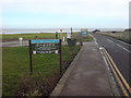
9
The end of the B2231, at Leysdown-on-Sea
Looking back towards the village.
Image: © David Purchase
Taken: 19 Oct 2014
0.09 miles
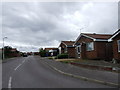
10
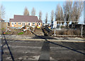
Residential development, Shellness Road/Wing Road
Planning permission was granted, after an appeal, by The Planning Inspectorate, after Swale Borough Council had refused permission under application number
SW/12/1483 for the “residential development of four 2 bedroom and one 3 bedroom single storey dwellings together with all associated driveway parking”. The location was given as land Adjoining Community Hall, Shellness Road/Wing Road. This view is from Wing Road.
Image: © John Baker
Taken: 17 Jan 2017
0.11 miles