IMAGES TAKEN NEAR TO
Lawday Avenue, SHEERNESS, ME12 4BJ
Introduction
This page details the photographs taken nearby to Lawday Avenue, ME12 4BJ by members of the Geograph project.
The Geograph project started in 2005 with the aim of publishing, organising and preserving representative images for every square kilometre of Great Britain, Ireland and the Isle of Man.

There are currently over 7.5m images from over14,400 individuals and you can help contribute to the project by visiting https://www.geograph.org.uk
Image Map
Images are licensed for reuse under creativecommons.org/licenses/by-sa/2.0
Notes
- Clicking on the map will re-center to the selected point.
- The higher the marker number, the further away the image location is from the centre of the postcode.
Image Listing (16 Images Found)
Images are licensed for reuse under creativecommons.org/licenses/by-sa/2.0
Image
Details
Distance
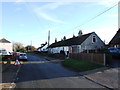
1
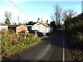
Marrowbone Hill, Plough Road
Just to the west of Cripps Farm. It all looks delightfully tranquil but the beyond the left hand side of the road, the fields have been ravaged by Kingsborough Manor - a large estate of new houses.
Image: © John Baker
Taken: 7 Oct 2012
0.10 miles
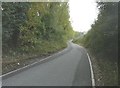
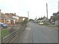
2
Plough Road
Plough Road leads from Minster-in-Sheppey to Eastchurch.
Image: © Marathon
Taken: 4 Feb 2017
0.11 miles
3
Kingsborough Manor Community Woodland
On Plough Road. Newly planted woodland on footpath from Plough Road to Eastchurch Road.
Image: © David Anstiss
Taken: 24 Jan 2009
0.13 miles
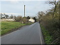
5
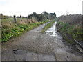
Track off Plough Road
This is the view near Kingsbury Caravan Park from Plough Road which leads from Minster-in-Sheppey to Eastchurch.
Image: © Marathon
Taken: 4 Feb 2017
0.15 miles
6
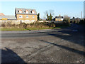
Looking east along Eastchurch Road (B2008)
My previous view of Image showed this house under construction; now it has been completed. It is situated on the Kingsborough Manor housing estate.
Image: © John Baker
Taken: 17 Jan 2017
0.16 miles
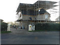
7
Looking east along Eastchurch Road (B2008)
The house, under construction, is situated on the Kingsborough Manor housing estate.
Image: © John Baker
Taken: 27 Sep 2015
0.17 miles
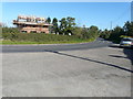
8
Plough Road
Just to the left of the last car on the right is a white post, whose iron work above it used to support the sign of The Plough Inn. The Plough Inn was demolished, as described in Swale Borough Council’s planning application SW/07/1192 as the “demolition of existing building and erection of detached house”. The location provided was land adjacent ‘The Plough’, Plough Road, Minster.
Image: © John Baker
Taken: 7 Oct 2012
0.17 miles
9
Alterations to Norwood Cottage, Eastchurch Road
Image: © John Baker
Taken: 17 Jan 2017
0.19 miles