IMAGES TAKEN NEAR TO
Bayliss Grove, SHEERNESS, ME12 3UJ
Introduction
This page details the photographs taken nearby to Bayliss Grove, ME12 3UJ by members of the Geograph project.
The Geograph project started in 2005 with the aim of publishing, organising and preserving representative images for every square kilometre of Great Britain, Ireland and the Isle of Man.

There are currently over 7.5m images from over14,400 individuals and you can help contribute to the project by visiting https://www.geograph.org.uk
Image Map
Images are licensed for reuse under creativecommons.org/licenses/by-sa/2.0
Notes
- Clicking on the map will re-center to the selected point.
- The higher the marker number, the further away the image location is from the centre of the postcode.
Image Listing (24 Images Found)
Images are licensed for reuse under creativecommons.org/licenses/by-sa/2.0
Image
Details
Distance
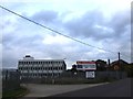
1
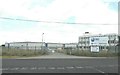
HBC Global Engineering Solutions
Situated in Power Station Road and subject to local debate to use the site for a Morrison supermarket http://www.kentonline.co.uk/times_guardian/news/2012/may/22/petition_to_support_morrisons.aspx
Image: © John Baker
Taken: 22 Aug 2012
0.04 miles
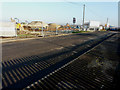
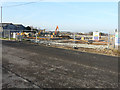
2
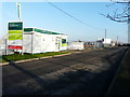
Building site, Power Station Road
Planning permission has been granted by Swale Borough Council under application number 15/508025/REM as the “approval of reserved matters for residential redevelopment of 142 dwellings together with access roads, footpaths, drainage, associated car/bicycle parking provision, groundwork's, landscaping, open space and infrastructure (all matters being sought except access)”. The location is the former Image site.
Image: © John Baker
Taken: 17 Jan 2017
0.05 miles
3
Building site, Power Station Road
Planning permission has been granted by Swale Borough Council under application number 15/508025/REM as the “approval of reserved matters for residential redevelopment of 142 dwellings together with access roads, footpaths, drainage, associated car/bicycle parking provision, groundwork's, landscaping, open space and infrastructure (all matters being sought except access)”. The location is the former Image site.
Image: © John Baker
Taken: 17 Jan 2017
0.06 miles
4
Derelict Industrial Site near Halfway
This site was most recently used by HBC Engineering.
Image: © Chris Whippet
Taken: 26 Oct 2013
0.06 miles
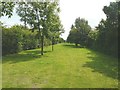
5
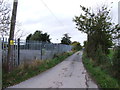
Former trackbed of Sheppey Light Railway
As seen across William Rigby Road near to its junction with Power Station Road (to the right). According to http://www.sheppeywebsite.co.uk/index.php?id=95 The Sheppey Light Railway opened on 1 August 1901 and closed on 4 December 1950. The total length was 8 miles 52 chains. It ran from Queenborough (where there was a north-facing bay platform on the east side of the station) to Leysdown with intermediate stations at Sheerness East, East Minster-on-Sea (which was actually west of Minster), Minster-on-Sea (they're only given as Minster in the link), Brambledown Halt, Eastchurch and Harty Road Halt. Today, one can trace most of the route from the air and on the Ordnance Survey map (Explorer 149). On the ground, one can find sections overgrown with grass, brambles and trees, sections built over, sections concreted over to form a permanent way or landscaped to form paths for pedestrians (as here).
Image: © John Baker
Taken: 26 Jul 2012
0.07 miles
6
Former trackbed of Sheppey Light Railway
According to http://www.sheppeywebsite.co.uk/index.php?id=95 The Sheppey Light Railway opened on 1 August 1901 and closed on 4 December 1950. The total length was 8 miles 52 chains. It ran from Queenborough (where there was a north-facing bay platform on the east side of the station) to Leysdown with intermediate stations at Sheerness East, East Minster-on-Sea (which was actually west of Minster), Minster-on-Sea (they're only given as Minster in the link), Brambledown Halt, Eastchurch and Harty Road Halt. Today, one can trace most of the route from the air and on the Ordnance Survey map (Explorer 149). On the ground, one can find sections overgrown with grass, brambles and trees, sections built over, sections concreted over to form a permanent way or landscaped to form paths for pedestrians (as here).
Image: © John Baker
Taken: 26 Jul 2012
0.08 miles
7
Building site, Power Station Road
Planning permission has been granted by Swale Borough Council under application number 15/508025/REM as the “approval of reserved matters for residential redevelopment of 142 dwellings together with access roads, footpaths, drainage, associated car/bicycle parking provision, groundwork's, landscaping, open space and infrastructure (all matters being sought except access)”. The location is the former Image site.
Image: © John Baker
Taken: 17 Jan 2017
0.08 miles
8
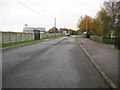
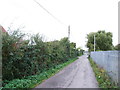
Sheppey Light Railway: Former route along Power Station Road
The Sheppey Light Railway ran from Queenborough to Leysdown-on-Sea. It was built to the designs of the renowned light railway engineer, Colonel Fred Holman Stephens, and was opened in 1901. Traffic was never busy on the line and it was taken over by the South Eastern and Chatham Railway in 1905, finally closing in 1950.
This view shows the route of the dismantled railway, east of the former Sheerness East station, along Power Station Road.
Image: © Nigel Cox
Taken: 24 Nov 2013
0.08 miles