IMAGES TAKEN NEAR TO
Primrose Way, SHEERNESS, ME12 3TR
Introduction
This page details the photographs taken nearby to Primrose Way, ME12 3TR by members of the Geograph project.
The Geograph project started in 2005 with the aim of publishing, organising and preserving representative images for every square kilometre of Great Britain, Ireland and the Isle of Man.

There are currently over 7.5m images from over14,400 individuals and you can help contribute to the project by visiting https://www.geograph.org.uk
Image Map
Images are licensed for reuse under creativecommons.org/licenses/by-sa/2.0
Notes
- Clicking on the map will re-center to the selected point.
- The higher the marker number, the further away the image location is from the centre of the postcode.
Image Listing (20 Images Found)
Images are licensed for reuse under creativecommons.org/licenses/by-sa/2.0
Image
Details
Distance
1
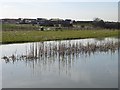
Lake behind new development on Plover Road
This lake is on the land accessed from Image There is also a footpath behind the photographer which runs from Parish Road (houses on the right) and Scocles Road. The whole area is under development with roads not yet mapped but I imagine this will remain as a recreational area. Image is the building on the left.
Image: © Penny Mayes
Taken: 8 Mar 2007
0.06 miles
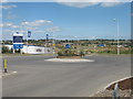
2
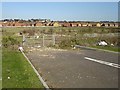
Dead end from new roundabout
Thistle Hill Way has been completed with several small roundabouts along it, presumably for access to the planned housing developments not yet built. This branch off a roundabout is a bit of a puzzle, leading as it does to an area currently used as recreational land and including a lake but I guess they will need access for tidying it up (I hope) and maintenance.
Image: © Penny Mayes
Taken: 8 Mar 2007
0.09 miles
3
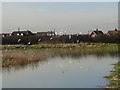
Lake near Parish Road
Beside the footpath from Parish Road to Scocles Road. This area will soon be surrounded by new housing developments.
Image: © Penny Mayes
Taken: 8 Mar 2007
0.09 miles
4
Gulls on the lake
The houses beyond are on Parish Road.
Image: © Penny Mayes
Taken: 8 Mar 2007
0.09 miles
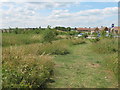
5

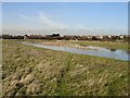
Footpath from Parish Road to Scocles Road
Across the rough ground with the lake amidst the new housing developments in this square. See other pics in Image
Image: © Penny Mayes
Taken: 8 Mar 2007
0.10 miles
6
Roundabout on Thistle Hill Way
This new roundabout is on Thistle Hill Way leading from B2231 Lower Road to Minster. Plover Road leads left into Priory Meadows new housing estate, and on to Sheppey Community Hospital. The road on the right is not named and more estate housing is still being built.
Image: © David Anstiss
Taken: 10 Jul 2009
0.12 miles
7

Construction of Priory Meadow, Minster
Bovis Homes is building a large estate on Thistle Hill Way, near Minster. This road is still unnamed.
Image: © David Anstiss
Taken: 10 Jul 2009
0.13 miles
8

New housing on Plover Road
Next to Image This development joins up with those on Thistle Hill Way.
Image: © Penny Mayes
Taken: 8 Mar 2007
0.16 miles

10
Footpath in Thistle Hill Community Woodland
This footpath leads through a wide band of newly planted (2002) woodland, leading from Scocles Road, near Scocles Farm to Thistle Hill Way. Past a carpark for woodland visitors, then onto another band of woodland on a path to Barton Hill Drive, Minster. Several grass paths lead through the woodland. Pleasant dog walking for new owners of new housing estates nearby.
Image: © David Anstiss
Taken: 10 Jul 2009
0.16 miles