IMAGES TAKEN NEAR TO
Greyhound Road, SHEERNESS, ME12 3SP
Introduction
This page details the photographs taken nearby to Greyhound Road, ME12 3SP by members of the Geograph project.
The Geograph project started in 2005 with the aim of publishing, organising and preserving representative images for every square kilometre of Great Britain, Ireland and the Isle of Man.

There are currently over 7.5m images from over14,400 individuals and you can help contribute to the project by visiting https://www.geograph.org.uk
Image Map
Images are licensed for reuse under creativecommons.org/licenses/by-sa/2.0
Notes
- Clicking on the map will re-center to the selected point.
- The higher the marker number, the further away the image location is from the centre of the postcode.
Image Listing (15 Images Found)
Images are licensed for reuse under creativecommons.org/licenses/by-sa/2.0
Image
Details
Distance
2
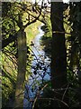
Drain south of Lower Road
Viewed through the hedge on Elmley Road
Image: © Penny Mayes
Taken: 8 Mar 2007
0.12 miles
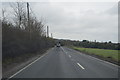
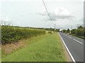
3
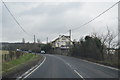
A2500 Lower Road
Heading towards Eastchurch and Leysdown.
Image: © Robin Webster
Taken: 16 May 2018
0.14 miles
4
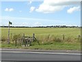
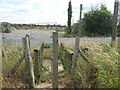
Stile beside Lower Road (B2231)
The fingerpost points towards Image
Image: © John Baker
Taken: 22 Aug 2012
0.16 miles
6
Footbridge near Lower Road
The bridge is at the end of a path from Elm Lane, Minster. It crosses over a ditch alongside the B2231 Lower Road.
Image: © David Anstiss
Taken: 10 Jul 2009
0.16 miles
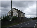
8
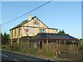
The Elm Tree
A disused pub on the Lower Road.
Image: © Penny Mayes
Taken: 8 Mar 2007
0.17 miles
9
Elm Tree Inn, near Brambledown, Sheppey
Image: © Chris Whippet
Taken: 17 Jul 2009
0.18 miles
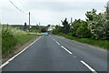
10
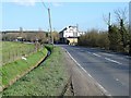
Lower Road (B2231), Brambledown
In the distance is Image
Image: © John Baker
Taken: 22 Aug 2012
0.18 miles