IMAGES TAKEN NEAR TO
Lower Road, SHEERNESS, ME12 3RR
Introduction
This page details the photographs taken nearby to Lower Road, ME12 3RR by members of the Geograph project.
The Geograph project started in 2005 with the aim of publishing, organising and preserving representative images for every square kilometre of Great Britain, Ireland and the Isle of Man.

There are currently over 7.5m images from over14,400 individuals and you can help contribute to the project by visiting https://www.geograph.org.uk
Image Map
Images are licensed for reuse under creativecommons.org/licenses/by-sa/2.0
Notes
- Clicking on the map will re-center to the selected point.
- The higher the marker number, the further away the image location is from the centre of the postcode.
Image Listing (10 Images Found)
Images are licensed for reuse under creativecommons.org/licenses/by-sa/2.0
Image
Details
Distance
2
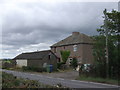
Cottages on Lower Road, near Wallend Farm
Image: © Chris Whippet
Taken: 17 Jul 2009
0.01 miles
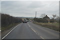
4
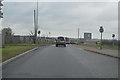
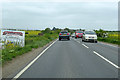
Friday afternoon Boot-fair on B2231 Lower Road
This boot-fair opposite Wall End Farm, has just started this summer. Starting at 12am and onwards until no more visitors. The B2231 Lower Road leads straight on to the roundabout for the A249 Sheppey bridge or Queenborough and Sheerness-on-Sea towns.
Image: © David Anstiss
Taken: 10 Jul 2009
0.04 miles
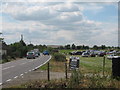
7
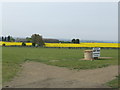
Boot Fair site near Wallend Farm
Just off the B2231 Eastchurch road, Sheppey.
Image: © Jonathan Billinger
Taken: 25 Apr 2007
0.20 miles