IMAGES TAKEN NEAR TO
Oak Lane, SHEERNESS, ME12 3QS
Introduction
This page details the photographs taken nearby to Oak Lane, ME12 3QS by members of the Geograph project.
The Geograph project started in 2005 with the aim of publishing, organising and preserving representative images for every square kilometre of Great Britain, Ireland and the Isle of Man.

There are currently over 7.5m images from over14,400 individuals and you can help contribute to the project by visiting https://www.geograph.org.uk
Image Map
Images are licensed for reuse under creativecommons.org/licenses/by-sa/2.0
Notes
- Clicking on the map will re-center to the selected point.
- The higher the marker number, the further away the image location is from the centre of the postcode.
Image Listing (17 Images Found)
Images are licensed for reuse under creativecommons.org/licenses/by-sa/2.0
Image
Details
Distance
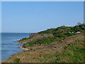
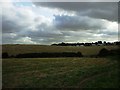
3
Oak Lane, East End
There is a caravan park between the lane and the cliff top.
Image: © David Martin
Taken: 16 Mar 2023
0.15 miles
8
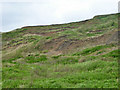
Unstable clay cliff, Round Hill
East of cliff top permanent housing, no attempt has been made to stabilize the cliff with a drainage system or sea wall, and this is the result.
Image: © Robin Webster
Taken: 16 May 2018
0.21 miles