IMAGES TAKEN NEAR TO
Oak Lane, SHEERNESS, ME12 3QN
Introduction
This page details the photographs taken nearby to Oak Lane, ME12 3QN by members of the Geograph project.
The Geograph project started in 2005 with the aim of publishing, organising and preserving representative images for every square kilometre of Great Britain, Ireland and the Isle of Man.

There are currently over 7.5m images from over14,400 individuals and you can help contribute to the project by visiting https://www.geograph.org.uk
Image Map
Images are licensed for reuse under creativecommons.org/licenses/by-sa/2.0
Notes
- Clicking on the map will re-center to the selected point.
- The higher the marker number, the further away the image location is from the centre of the postcode.
Image Listing (16 Images Found)
Images are licensed for reuse under creativecommons.org/licenses/by-sa/2.0
Image
Details
Distance
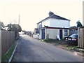
4
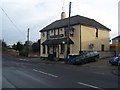
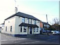
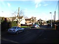
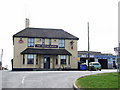
The British Queen Pub, Minster
On junction of 115 Chequers Road (in front) and Elm Lane (going behind pub). Opposite Elm Lane is Oak Lane, with pub car park and leads to a caravan park as well as more housing.
Image: © David Anstiss
Taken: 24 Jan 2009
0.06 miles
8
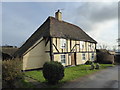
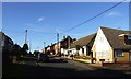
Little Woottons, Minster-in-Sheppey
This attractive house is to be seen in Elm Lane.
Image: © Marathon
Taken: 4 Feb 2017
0.12 miles