IMAGES TAKEN NEAR TO
Parish Road, SHEERNESS, ME12 3NG
Introduction
This page details the photographs taken nearby to Parish Road, ME12 3NG by members of the Geograph project.
The Geograph project started in 2005 with the aim of publishing, organising and preserving representative images for every square kilometre of Great Britain, Ireland and the Isle of Man.

There are currently over 7.5m images from over14,400 individuals and you can help contribute to the project by visiting https://www.geograph.org.uk
Image Map
Images are licensed for reuse under creativecommons.org/licenses/by-sa/2.0
Notes
- Clicking on the map will re-center to the selected point.
- The higher the marker number, the further away the image location is from the centre of the postcode.
Image Listing (24 Images Found)
Images are licensed for reuse under creativecommons.org/licenses/by-sa/2.0
Image
Details
Distance
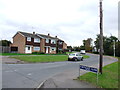
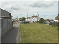
1
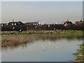
Gulls on the lake
The houses beyond are on Parish Road.
Image: © Penny Mayes
Taken: 8 Mar 2007
0.07 miles
2
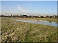
Lake near Parish Road
Beside the footpath from Parish Road to Scocles Road. This area will soon be surrounded by new housing developments.
Image: © Penny Mayes
Taken: 8 Mar 2007
0.08 miles
3
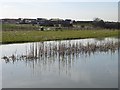
Lake behind new development on Plover Road
This lake is on the land accessed from Image There is also a footpath behind the photographer which runs from Parish Road (houses on the right) and Scocles Road. The whole area is under development with roads not yet mapped but I imagine this will remain as a recreational area. Image is the building on the left.
Image: © Penny Mayes
Taken: 8 Mar 2007
0.11 miles
4
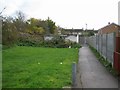
Sheppey Light Railway: Former route south-east of Minster Road
The Sheppey Light Railway ran from Queenborough to Leysdown-on-Sea. It was built to the designs of the renowned light railway engineer, Colonel Fred Holman Stephens, and was opened in 1901. Traffic was never busy on the line and it was taken over by the South Eastern and Chatham Railway in 1905, finally closing in 1950.
This open grassy patch is on the former route south-east of Minster Road and trains would have passed through where the distant terrace of houses, off Fleetwood Close, has since been built.
Image: © Nigel Cox
Taken: 24 Nov 2013
0.11 miles
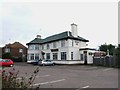
8
Sheppey Light Railway: Site of the former East Minster station
The Sheppey Light Railway ran from Queenborough to Leysdown-on-Sea. It was built to the designs of the renowned light railway engineer, Colonel Fred Holman Stephens, and was opened in 1901. Traffic was never busy on the line and it was taken over by the South Eastern and Chatham Railway in 1905, finally closing in 1950.
The Costcutter store more or less occupies the site of the former East Minster station with the track crossing Minster Road here. Curiously, and possibly confusingly for the stranger heading east on a train towards Leysdown, East Minster station was reached before Minster on Sea station.
Image: © Nigel Cox
Taken: 24 Nov 2013
0.13 miles
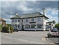
9
Costcutter Post Office Stores, Minster Road
The grassed area was the former trackbed of The Sheppey Light Railway, which would have crossed the road ahead and continued on its way to the left of the shop (where the tree is), after stopping at the station of East Minster-on-Sea just across the road. According to http://www.sheppeywebsite.co.uk/index.php?id=95 the railway opened on 1 August 1901 and closed on 4 December 1950. The total length was 8 miles 52 chains. It ran from Queenborough (where there was a north-facing bay platform on the east side of the station) to Leysdown with intermediate stations at Sheerness East, East Minster-on-Sea (which was actually west of Minster), Minster-on-Sea (they're only given as Minster in the link), Brambledown Halt, Eastchurch and Harty Road Halt. Today, one can trace most of the route from the air and on the Ordnance Survey map (Explorer 149). On the ground, one can find sections overgrown with grass, brambles and trees, sections built over, sections concreted over to form a permanent way or landscaped to form paths for pedestrians.
Image: © John Baker
Taken: 22 Aug 2012
0.14 miles
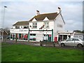
10

Looking east from Fleetwood Close
Towards an overgrown hedge which marks the former trackbed of The Sheppey Light Railway. According to http://www.sheppeywebsite.co.uk/index.php?id=95 the railway opened on 1 August 1901 and closed on 4 December 1950. The total length was 8 miles 52 chains. It ran from Queenborough (where there was a north-facing bay platform on the east side of the station) to Leysdown with intermediate stations at Sheerness East, East Minster-on-Sea (which was actually west of Minster), Minster-on-Sea (they're only given as Minster in the link), Brambledown Halt, Eastchurch and Harty Road Halt. Today, one can trace most of the route from the air and on the Ordnance Survey map (Explorer 149). On the ground, one can find sections overgrown with grass, brambles and trees (as here), sections built over, sections concreted over to form a permanent way or landscaped to form paths for pedestrians.
Image: © John Baker
Taken: 22 Aug 2012
0.14 miles