IMAGES TAKEN NEAR TO
Rosemary Avenue, SHEERNESS, ME12 3HT
Introduction
This page details the photographs taken nearby to Rosemary Avenue, ME12 3HT by members of the Geograph project.
The Geograph project started in 2005 with the aim of publishing, organising and preserving representative images for every square kilometre of Great Britain, Ireland and the Isle of Man.

There are currently over 7.5m images from over14,400 individuals and you can help contribute to the project by visiting https://www.geograph.org.uk
Image Map
Images are licensed for reuse under creativecommons.org/licenses/by-sa/2.0
Notes
- Clicking on the map will re-center to the selected point.
- The higher the marker number, the further away the image location is from the centre of the postcode.
Image Listing (10 Images Found)
Images are licensed for reuse under creativecommons.org/licenses/by-sa/2.0
Image
Details
Distance
2
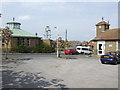
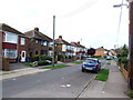
St Peter's church, Halfway, Sheppey
The church is the building on the left, while the one on the right is the original church, now the function hall for the new building.
Image: © Jonathan Billinger
Taken: 25 Apr 2007
0.08 miles
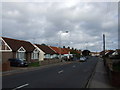
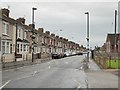
6
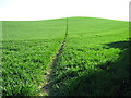
Footpath over Furze Hill
This footpath goes from Holmside Avenue, Halfway, then goes over the hill to Queenborough Road, near the Neatscourt Cottages.
Image: © David Anstiss
Taken: 26 Apr 2009
0.21 miles
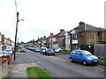
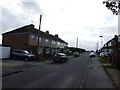
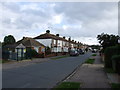
10
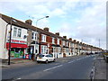
Halfway Houses: Queenborough Road
Terraced housing in one of the more populated areas of Sheppey.
'Halfway' - I suppose - because this was once mid-way between Minster and Queenborough. The name makes less sense now that Minster has expanded westward.
Image: © Stefan Czapski
Taken: 29 Jul 2017
0.24 miles