IMAGES TAKEN NEAR TO
The Crescent, SHEERNESS, ME12 3BQ
Introduction
This page details the photographs taken nearby to The Crescent, ME12 3BQ by members of the Geograph project.
The Geograph project started in 2005 with the aim of publishing, organising and preserving representative images for every square kilometre of Great Britain, Ireland and the Isle of Man.

There are currently over 7.5m images from over14,400 individuals and you can help contribute to the project by visiting https://www.geograph.org.uk
Image Map
Images are licensed for reuse under creativecommons.org/licenses/by-sa/2.0
Notes
- Clicking on the map will re-center to the selected point.
- The higher the marker number, the further away the image location is from the centre of the postcode.
Image Listing (27 Images Found)
Images are licensed for reuse under creativecommons.org/licenses/by-sa/2.0
Image
Details
Distance
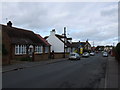
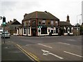
3
Crossroads at Halfway Houses
Seen from Minster Road (B2008) with Halfway Road (A250) to the right. The crossroads are controlled by traffic lights with Queenborough Road (A250) just seen beyond them. The Crescent is out of sight to the left.
Image: © John Baker
Taken: 7 Oct 2012
0.03 miles
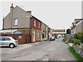
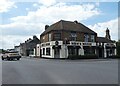
5

The Halfway House Public House
At Halfway House crossroads. On Halfway Road (A250).
Left goes to Minster, right heads to dual carriageway off the island.
Image: © David Anstiss
Taken: 22 Oct 2008
0.04 miles
6
Mem's Mezze, Halfway Houses
Occupying a former public house: Image
Image: © Roger Cornfoot
Taken: 21 Jun 2024
0.04 miles
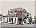
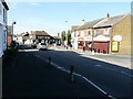
8
Halfway Houses: The Halfway House
Not being a local the photographer is unsure as to just which places Halfway Houses is halfway between. Queenborough and Minster certainly, but Sheerness and what, both Queenborough and Minster avoiding the coast? Whatever, the A250 road comes up from Queenborough to the left and makes a right angled turn at the junction to head off northwards towards Sheerness to the right. The pub is inevitably The Halfway House, but it is not the original as Victorian Ordnance Survey maps show one on the south side of the road and a blank space where the current one is now.
Image: © Nigel Cox
Taken: 24 Nov 2013
0.04 miles
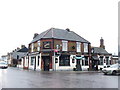
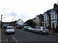
10
Halfway Houses
Looking south down Halfway Road to its junction with Minster Road and Queenborough Road in the NW corner of the square.
Image: © Penny Mayes
Taken: 2 Aug 2005
0.05 miles