IMAGES TAKEN NEAR TO
The Willows, SHEERNESS, ME12 2FH
Introduction
This page details the photographs taken nearby to The Willows, ME12 2FH by members of the Geograph project.
The Geograph project started in 2005 with the aim of publishing, organising and preserving representative images for every square kilometre of Great Britain, Ireland and the Isle of Man.

There are currently over 7.5m images from over14,400 individuals and you can help contribute to the project by visiting https://www.geograph.org.uk
Image Map
Images are licensed for reuse under creativecommons.org/licenses/by-sa/2.0
Notes
- Clicking on the map will re-center to the selected point.
- The higher the marker number, the further away the image location is from the centre of the postcode.
Image Listing (27 Images Found)
Images are licensed for reuse under creativecommons.org/licenses/by-sa/2.0
Image
Details
Distance
2
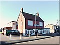
Minster on Sea: The White House
The White House is now a Bangladeshi and Indian restaurant but once was an isolated house at the Scrapsgate end of the old sea defence embankment across Minster Marshes. The Ordnance Survey map of 1965 shows it as "White House".
Image: © Nigel Cox
Taken: 24 Nov 2013
0.05 miles
3
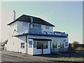
The White House Pub, Scrapsgate
In an area known as Scrapsgate, you can see the sea wall in the background
Image: © Martin Coull
Taken: 9 Nov 2006
0.06 miles
4
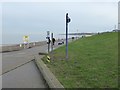
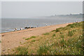
The promenade at Minster
The crumbling cliffs of north-east Sheppey can be seen in the distance. Despite the signs there was nobody in the sea at Minster Leas beach on this rather chilly February day.
Image: © Marathon
Taken: 4 Feb 2017
0.09 miles
5
The promenade at Minster
The crumbling cliffs of north-east Sheppey can be seen in the distance. Despite the signs there was nobody in the sea at Minster Leas beach on this rather chilly February day.
Image: © Marathon
Taken: 4 Feb 2017
0.09 miles
6
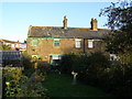
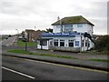
Coastguards Cottages, Scrapsgate
Head Coastguard lived in left cottage from 1795 to at least 1861 (1861 Census). Probably built mid 1700s. Total of eight cottages all of which were for Coastguards.
Image: © Martin Coull
Taken: 9 Nov 2006
0.09 miles
7
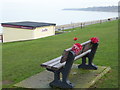
Memorial bench on The Leas at Minster
All the benches along The Leas had flowers attached to them like this one as they are memorial benches. However, there has been a certain amount of disquiet with the Council who have recently put up the charges for installing a bench and then banned the installation of any more benches. That was in 2014 but judging by the fact that flowers were attached to every bench, people still find that they are a way to remember their loved ones - see http://www.kentonline.co.uk/sheerness/news/rise-in-charges-for-memorial-11988/ and http://www.kentonline.co.uk/sheerness/news/kirsty-jeffrey-memorial-appeal-18841/
The crumbling cliffs of north-east Sheppey can be seen in the distance.
Image: © Marathon
Taken: 4 Feb 2017
0.10 miles
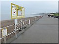
9
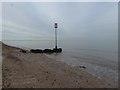
The beach at Minster
Essex can just be made out on the far side of the Thames Estuary.
Image: © Marathon
Taken: 4 Feb 2017
0.11 miles