IMAGES TAKEN NEAR TO
Edwina Avenue, SHEERNESS, ME12 2EB
Introduction
This page details the photographs taken nearby to Edwina Avenue, ME12 2EB by members of the Geograph project.
The Geograph project started in 2005 with the aim of publishing, organising and preserving representative images for every square kilometre of Great Britain, Ireland and the Isle of Man.

There are currently over 7.5m images from over14,400 individuals and you can help contribute to the project by visiting https://www.geograph.org.uk
Image Map
Images are licensed for reuse under creativecommons.org/licenses/by-sa/2.0
Notes
- Clicking on the map will re-center to the selected point.
- The higher the marker number, the further away the image location is from the centre of the postcode.
Image Listing (14 Images Found)
Images are licensed for reuse under creativecommons.org/licenses/by-sa/2.0
Image
Details
Distance
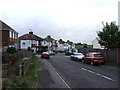
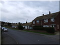
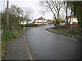
2
Bridge between Marian Avenue and Ripney Hill Farm
Image: © Chris Whippet
Taken: 26 Oct 2013
0.07 miles
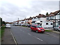
3
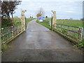
Minster on Sea: Ripney Hill Farm
There has been a farm on Ripney Hill since long before the residential development of Minster started. The horses' heads on the gate pillars indicate one of its current functions as an equestrian centre. This is the view from the northern end of Marian Avenue.
Image: © Nigel Cox
Taken: 24 Nov 2013
0.08 miles
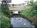
7
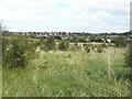
Looking towards Scrapsgate Road
Across scrubland below the former trackbed of The Sheppey Light Railway. According to http://www.sheppeywebsite.co.uk/index.php?id=95 the railway opened on 1 August 1901 and closed on 4 December 1950. The total length was 8 miles 52 chains. It ran from Queenborough (where there was a north-facing bay platform on the east side of the station) to Leysdown with intermediate stations at Sheerness East, East Minster-on-Sea (which was actually west of Minster), Minster-on-Sea (they're only given as Minster in the link), Brambledown Halt, Eastchurch and Harty Road Halt. Today, one can trace most of the route from the air and on the Ordnance Survey map (Explorer 149). On the ground, one can find sections overgrown with grass, brambles and trees, sections built over, sections concreted over to form a permanent way or landscaped to form paths for pedestrians.
Image: © John Baker
Taken: 22 Aug 2012
0.11 miles
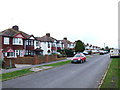
8
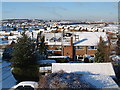
Minster on Sea Snow Scene
View looking West above the roof tops of Minster on Sea
Image: © Steve Hollis
Taken: 28 Dec 2003
0.11 miles
9
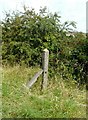
Southern Region fence post
Beside the former trackbed of The Sheppey Light Railway. According to http://www.sheppeywebsite.co.uk/index.php?id=95 the railway opened on 1 August 1901 and closed on 4 December 1950. The total length was 8 miles 52 chains. It ran from Queenborough (where there was a north-facing bay platform on the east side of the station) to Leysdown with intermediate stations at Sheerness East, East Minster-on-Sea (which was actually west of Minster), Minster-on-Sea (they're only given as Minster in the link), Brambledown Halt, Eastchurch and Harty Road Halt. Today, one can trace most of the route from the air and on the Ordnance Survey map (Explorer 149). On the ground, one can find sections overgrown with grass, brambles and trees, sections built over, sections concreted over to form a permanent way or landscaped to form paths for pedestrians. There was another post nearby.
Image: © John Baker
Taken: 22 Aug 2012
0.12 miles
10
Sheppey Light Railway: Site of the former Scrapsgate crossing
The Sheppey Light Railway ran from Queenborough to Leysdown-on-Sea. It was built to the designs of the renowned light railway engineer, Colonel Fred Holman Stephens, and was opened in 1901. Traffic was never busy on the line and it was taken over by the South Eastern and Chatham Railway in 1905, finally closing in 1950.
The photographer is uncertain as to whether the crossing was made by a bridge or a level crossing, and the situation is not helped by the fact that the Ordnance Survey large scale maps available online either show the railway as working and the road as a track before the houses were built (1933), or the railway dismantled but with the houses built and the road formalized (1965).
Image: © Nigel Cox
Taken: 24 Nov 2013
0.12 miles