IMAGES TAKEN NEAR TO
Marine Parade, SHEERNESS, ME12 2BX
Introduction
This page details the photographs taken nearby to Marine Parade, ME12 2BX by members of the Geograph project.
The Geograph project started in 2005 with the aim of publishing, organising and preserving representative images for every square kilometre of Great Britain, Ireland and the Isle of Man.

There are currently over 7.5m images from over14,400 individuals and you can help contribute to the project by visiting https://www.geograph.org.uk
Image Map
Images are licensed for reuse under creativecommons.org/licenses/by-sa/2.0
Notes
- Clicking on the map will re-center to the selected point.
- The higher the marker number, the further away the image location is from the centre of the postcode.
Image Listing (48 Images Found)
Images are licensed for reuse under creativecommons.org/licenses/by-sa/2.0
Image
Details
Distance
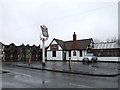
1
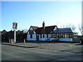
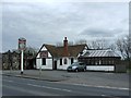
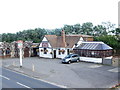
The Ship on Shore Pub, Sheerness
Marine Parade, Sheerness, ME12 2BX close the River Thames Tideway
Image: © canalandriversidepubs co uk
Taken: 7 Feb 2010
0.01 miles
2
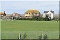
Living behind the sea wall
Houses and recreation ground beneath the sea defences at Sheerness
Image: © David Martin
Taken: 16 Mar 2023
0.04 miles
4
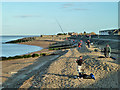
Beach fishing, Sheerness
A very popular sport here. They were hanging on to the last practical moment as the tide receded. Half an hour later they had all packed up and gone.
Image: © Robin Webster
Taken: 16 Feb 2014
0.04 miles
7
Sheppey - View along coastal path near Cheyney Rock
The coastal path (actually a Restricted Byway) on the western section of the northern coast of the Isle of Sheppey runs from Blue Town in Sheerness to Barton's Point to the north of Minster sandwiched between Marine Parade and the sea. It is seen here near Cheyney Rock looking westwards towards the Marine Town area of Sheerness.
Image: © Rob Farrow
Taken: 22 Jan 2023
0.05 miles
8
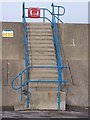
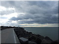
Steps on Seawall
Allow access from Car Park on Marine Parade, up to Esplanade. Footpath on sea wall.
Image: © David Anstiss
Taken: 24 Jan 2009
0.05 miles
10
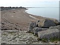
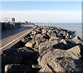
The beach near Sheerness
A very high sea wall has to be climbed over from Marine Parade to reach this stretch of beach opposite the Ship On Shore pub. The Isle of Grain can be seen in the distance beyond Sheerness and Essex is just visible to the right across the Thames Estuary.
Image: © Marathon
Taken: 4 Feb 2017
0.05 miles