IMAGES TAKEN NEAR TO
High Street, SHEERNESS, ME12 1UW
Introduction
This page details the photographs taken nearby to High Street, ME12 1UW by members of the Geograph project.
The Geograph project started in 2005 with the aim of publishing, organising and preserving representative images for every square kilometre of Great Britain, Ireland and the Isle of Man.

There are currently over 7.5m images from over14,400 individuals and you can help contribute to the project by visiting https://www.geograph.org.uk
Image Map
Images are licensed for reuse under creativecommons.org/licenses/by-sa/2.0
Notes
- Clicking on the map will re-center to the selected point.
- The higher the marker number, the further away the image location is from the centre of the postcode.
Image Listing (203 Images Found)
Images are licensed for reuse under creativecommons.org/licenses/by-sa/2.0
Image
Details
Distance
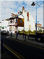
4
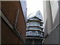
Windmill Sheerness
Currently being rebuilt following a fire on the 23rd January 2008.
Image: © PAUL FARMER
Taken: 3 May 2009
0.02 miles
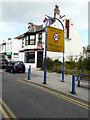
5
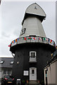
Replica smock mill rear of 111 High Street, Sheerness
Grade II Listed Great or Ride's smock mill. Work on building the Great mill was started by the millwright Humphrey of Cranbrook in 1813 and completed by Thomas Webb in 1816 who worked it until 1864 and was replaced by G Ride and Son. A steam engine was added in 1889 as auxiliary power. The mill was worked by wind until 1905, when the sails and stage were removed. It worked by steam engine until 1918 and was demolished in 1924 leaving only the brick base that served as a corn store through to the 1930s. The replica windmill was added in 2006-7 only to catch fire in January 2008; refurbishment being largely completed in May 2009.
Image: © Jo and Steve Turner
Taken: 29 Jun 2016
0.02 miles
6
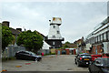
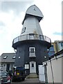
Old windmill, Sheerness
A grade II listed building, early 19th century.
Image: © Robin Webster
Taken: 16 May 2018
0.02 miles
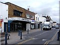
8
Usta Pizza and Charcoal Grill, High Street
Almost a year ago, the Image appeared to have gone out of business but now the boards over the ground floor window and door have been removed, it appears it has reopened (even though there is a “closed” notice in the window).
Image: © John Baker
Taken: 3 Oct 2017
0.02 miles
9
Usta Pizza and Charcoal Grill, High Street
Although the ground floor window and door are boarded over, one of the first floor windows is open, which seems to indicate that this floor is occupied. There is also a Rule & Rule estate agents for sale board, attached to the fence to the right of the building, which probably refers to the derelict land.
Image: © John Baker
Taken: 9 Oct 2016
0.03 miles